File:Maps of Western Sahara.png
Jump to navigation
Jump to search
Size of this preview: 799 × 235 pixels. Other resolutions: 320 × 94 pixels | 1,472 × 433 pixels.
Original file (1,472 × 433 pixels, file size: 98 KB, MIME type: image/png)
Captions
Captions
Add a one-line explanation of what this file represents

|
This map image could be re-created using vector graphics as an SVG file. This has several advantages; see Commons:Media for cleanup for more information. If an SVG form of this image is available, please upload it and afterwards replace this template with
{{vector version available|new image name}}.
It is recommended to name the SVG file “Maps of Western Sahara.svg”—then the template Vector version available (or Vva) does not need the new image name parameter. |
Summary
[edit]
| Description |
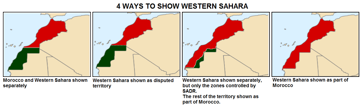
English: How Western Sahara is shown in maps |
| Date | |
| Source |
This file was derived from: Sahrawi Arab Democratic Republic (orthographic projection) highlighted.svg: _highlighted.svg) |
| Author | Universalis |
Licensing
[edit]
I, the copyright holder of this work, hereby publish it under the following license:
This file is licensed under the Creative Commons Attribution-Share Alike 4.0 International license.
- You are free:
- to share – to copy, distribute and transmit the work
- to remix – to adapt the work
- Under the following conditions:
- attribution – You must give appropriate credit, provide a link to the license, and indicate if changes were made. You may do so in any reasonable manner, but not in any way that suggests the licensor endorses you or your use.
- share alike – If you remix, transform, or build upon the material, you must distribute your contributions under the same or compatible license as the original.
File history
Click on a date/time to view the file as it appeared at that time.
| Date/Time | Thumbnail | Dimensions | User | Comment | |
|---|---|---|---|---|---|
| current | 02:50, 25 December 2020 | 1,472 × 433 (98 KB) | EdDakhla (talk | contribs) | More detailed version based of Locator Map (https://commons.wikimedia.org/wiki/File:LocationMorocco.svg) and de-facto map based on https://commons.wikimedia.org/wiki/File:Western_Sahara_conflict_map.svg | |
| 18:03, 1 June 2016 | 1,472 × 433 (36 KB) | Universalis (talk | contribs) | Better version | ||
| 18:10, 28 October 2015 | 1,472 × 433 (37 KB) | Universalis (talk | contribs) | User created page with UploadWizard |
You cannot overwrite this file.
File usage on Commons
The following page uses this file:
File usage on other wikis
The following other wikis use this file:
- Usage on ar.wikipedia.org
- Usage on eu.wikipedia.org
- Usage on fa.wikipedia.org
- Usage on it.wikivoyage.org
- Usage on pnb.wikipedia.org
- Usage on te.wikipedia.org
- Usage on ur.wikipedia.org