File:Maps template-history patch-en.svg
跳转到导航
跳转到搜索

此SVG文件的PNG预览的大小:800 × 585像素。 其他分辨率:320 × 234像素 | 640 × 468像素 | 1,024 × 749像素 | 1,280 × 937像素 | 2,560 × 1,873像素。
原始文件 (SVG文件,尺寸为820 × 600像素,文件大小:104 KB)
说明
说明
添加一行文字以描述该文件所表现的内容
摘要
[编辑]
| 描述 |
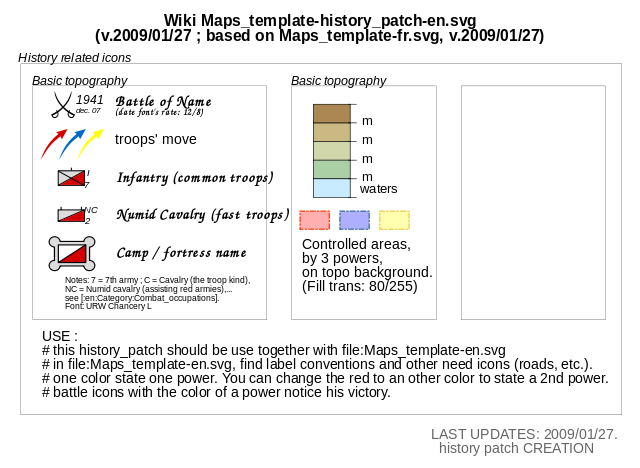
English: Template for the creation of geographic and topographic maps with the most common features used, following the current convention in WP-fr, and for some elements also in part of WP-de. Français : Modèle pour la création de cartes géographiques et topographiques avec les principaux éléments habituellement employés et qui suit les conventions cartographiques actuelles de WP-fr et pour certains éléments en partie dans WP-de. |
| 日期 | (UTC) |
| 来源 | Maps template-fr.svg |
| 作者 |
|
| 这是一张修改过的图片,这意味着它已在原版本的基础上通过软件进行了编辑,改动内容:Select some icones, order them : create an history_patch。其原始版本为:Maps template-fr.svg。修改者:Yug。
|
许可协议
[编辑]
我,本作品著作权人,特此采用以下许可协议发表本作品:

|
已授权您依据自由软件基金会发行的无固定段落及封面封底文字(Invariant Sections, Front-Cover Texts, and Back-Cover Texts)的GNU自由文件许可协议1.2版或任意后续版本的条款,复制、传播和/或修改本文件。该协议的副本请见“GNU Free Documentation License”。 |
| 本文件采用知识共享署名-相同方式共享 3.0 未本地化版本许可协议授权。 | ||
| ||
| 本许可协议标签作为GFDL许可协议更新的组成部分被添加至本文件。 |
您可以选择您需要的许可协议。
原始上传日志
[编辑]
This image is a derivative work of the following images:
- File:Maps_template-fr.svg licensed with Cc-by-2.5, Cc-by-2.5, GFDL, GFDL/en
- 2009-01-27T13:06:03Z Yug 1100x1500 (203738 Bytes) MINOR UPDATES: 2009/01/27. Add: port ; bat. judaisme, bat. chinese religions. Correct: terre principal fefee4 -> fefee9 (german usage) Add frames' titles, legend box. Move frames to more suitable place.
- 2008-09-04T00:08:14Z Sting 1100x1500 (176632 Bytes) Several little improvements
- 2008-07-15T14:45:27Z Sting 1100x1500 (170548 Bytes) Some improvements
- 2008-06-24T01:02:19Z Sting 1100x1500 (170673 Bytes) Valors for elevations and depths deleted to avoid confusion
- 2008-06-23T18:53:20Z Sémhur 1100x1500 (170836 Bytes) Change lighthouse icon, and decrease weight
- 2008-06-22T14:26:16Z Sting 1100x1500 (209351 Bytes) Additional topo colors for high elevations/permanent snow areas
- 2008-06-18T13:06:33Z Sting 1100x1500 (202960 Bytes) Additional modifications
- 2008-06-17T02:19:19Z Sting 1100x1500 (202606 Bytes) Some slight modifications
- 2008-06-13T14:51:52Z Sting 1100x1500 (202325 Bytes) Linear scales reduced to one type
- 2008-06-11T22:30:44Z Sting 1100x1500 (331785 Bytes) Some adjustments
- 2008-06-11T03:57:09Z Sting 1100x1500 (324893 Bytes) == Summary == {{Information |Description={{en|Template for the creation of geographic and topographic maps with the most common features used and following the convention to be used in the whole Wikimedia projet. *'''''Import
Uploaded with derivativeFX
文件历史
点击某个日期/时间查看对应时刻的文件。
| 日期/时间 | 缩略图 | 大小 | 用户 | 备注 | |
|---|---|---|---|---|---|
| 当前 | 2009年2月11日 (三) 21:09 | | 820 × 600(104 KB) | Stepshep(留言 | 贡献) | typos |
| 2009年1月27日 (二) 15:08 |  | 820 × 600(104 KB) | Yug(留言 | 贡献) | oups ^-^"... spelling mistake.... | |
| 2009年1月27日 (二) 15:05 |  | 820 × 600(104 KB) | Yug(留言 | 贡献) | {{Information |Description={{en|1=sadfg}} |Source=Own work by uploader |Author=Yug |Date=today |Permission= |other_versions= }} <!--{{ImageUpload|full}}--> |
您不可以覆盖此文件。
文件用途
没有页面使用本文件。
全域文件用途
以下其他wiki使用此文件:
- en.wikipedia.org上的用途
- id.wikipedia.org上的用途
- ru.wikipedia.org上的用途
- sl.wikipedia.org上的用途
- tg.wikipedia.org上的用途
- zh.wikipedia.org上的用途