File:Marianatrenchmap.png
跳转到导航
跳转到搜索

本预览的尺寸:460 × 599像素。 其他分辨率:184 × 240像素 | 369 × 480像素 | 756 × 984像素。
原始文件 (756 × 984像素,文件大小:758 KB,MIME类型:image/png)
说明
说明
添加一行文字以描述该文件所表现的内容
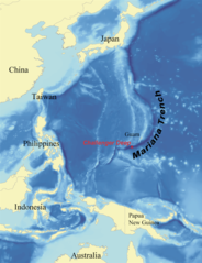
Map showing the Mariana Trench located southeast of Japan, east of Guam, and north of Papua New Guinea in the ocean territory of the Federated States of Mi
This is a picture of what it looks like from a satellite perspective.
摘要[编辑]
| 描述 |
English: Map showing the location of the Mariana Trench, designed as a replacement for en:Image:Mariana_trench_location.jpg. Français : Carte montrant la position de la fosse des Mariannes.
Latina: Haec charta locum Fossae Marianae demonstrat. |
| 日期 | |
| 来源 | self-made using data from NOAA[失效链接]. |
| 作者 | wallace |
许可协议[编辑]
I, Kmusser,本作品著作权人,特此采用以下许可协议发表本作品:

|
已授权您依据自由软件基金会发行的无固定段落及封面封底文字(Invariant Sections, Front-Cover Texts, and Back-Cover Texts)的GNU自由文件许可协议1.2版或任意后续版本的条款,复制、传播和/或修改本文件。该协议的副本请见“GNU Free Documentation License”。 |
| 本文件采用知识共享署名-相同方式共享 3.0 未本地化版本许可协议授权。 | ||
| 署名: I, Kmusser | ||
| ||
| 本许可协议标签作为GFDL许可协议更新的组成部分被添加至本文件。 |
您可以选择您需要的许可协议。
文件历史
点击某个日期/时间查看对应时刻的文件。
| 日期/时间 | 缩略图 | 大小 | 用户 | 备注 | |
|---|---|---|---|---|---|
| 当前 | 2020年6月14日 (日) 21:39 | | 756 × 984(758 KB) | Roy17(留言 | 贡献) | lossless crop from 2007 original, then annotated |
| 2016年6月2日 (四) 08:43 |  | 756 × 985(604 KB) | McGeddon(留言 | 贡献) | Cropped 1 % horizontally and < 1 % vertically using CropTool with precise mode. Crop out 1px black border. | |
| 2008年1月8日 (二) 06:09 |  | 761 × 989(598 KB) | Lee Carre(留言 | 贡献) | File size efficiency, reduced my 50KB without loss of image data. | |
| 2007年8月2日 (四) 15:26 |  | 773 × 1,000(658 KB) | Kmusser(留言 | 贡献) | {{Information |Description=Map showing the location of the Mariana Trench, designed as a replacement for en:Image:Mariana_trench_location.jpg. |Source=self-made using [http://www.ngdc.noaa.gov/seg/fliers/se-1104.shtml|data from |
您不可以覆盖此文件。
文件用途
以下2个页面使用本文件:
全域文件用途
以下其他wiki使用此文件:
- af.wikipedia.org上的用途
- ar.wikipedia.org上的用途
- ary.wikipedia.org上的用途
- ast.wikipedia.org上的用途
- azb.wikipedia.org上的用途
- az.wikipedia.org上的用途
- ba.wikipedia.org上的用途
- be-tarask.wikipedia.org上的用途
- be.wikipedia.org上的用途
- bg.wikipedia.org上的用途
- bn.wikipedia.org上的用途
- br.wikipedia.org上的用途
- bs.wikipedia.org上的用途
- ca.wikipedia.org上的用途
- ceb.wikipedia.org上的用途
- ce.wikipedia.org上的用途
- ckb.wikipedia.org上的用途
- cs.wikipedia.org上的用途
- da.wikipedia.org上的用途
- el.wikipedia.org上的用途
- en.wikipedia.org上的用途
- Challenger Deep
- Mariana Trench
- Abyssal plain
- Kaikō ROV
- User:Kmusser/Images
- Portal:Geology
- Nereus (underwater vehicle)
- Marianas Trench Marine National Monument
- Deep-sea community
- Wikipedia:ITN archives/2009/June
- User:DiverDave/Deep sea communities
- List of submarine topographical features
- User:سائغ/T
- Hadal zone microbial communities
- en.wikibooks.org上的用途
- en.wikinews.org上的用途
- eo.wikipedia.org上的用途
- es.wikipedia.org上的用途
查看本文件的更多全域用途。