File:Marka socken i Vilske härad.jpg
Jump to navigation
Jump to search
Size of this preview: 386 × 599 pixels. Other resolutions: 154 × 240 pixels | 574 × 891 pixels.
Original file (574 × 891 pixels, file size: 241 KB, MIME type: image/jpeg)
Captions
Captions
Add a one-line explanation of what this file represents
Summary
[edit]
| Description |
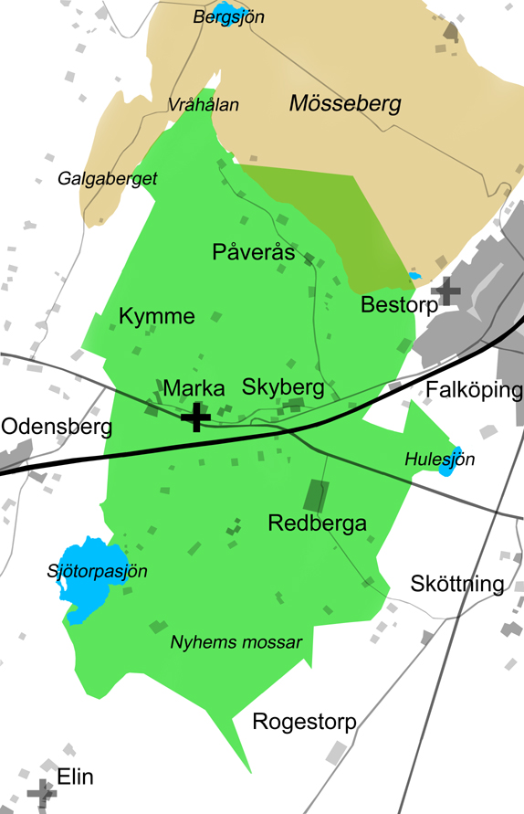
English: Map over Marka parish in Vilske hundred, Falköping municipality, Västergötland, Sweden. Scale 1:40,000. The area of Marka parish is marked green. The table-mountain Mösseberg is marked brownish. Lakes are blue. Marka church is marked with a black cross. Elin church-ruin and Bestorp church-ruin are marked with grey crosses. Railways, roads, villages, and farms are grey.
Svenska: Karta över Marka socken i Vilske härad, Falköpings kommun, Västergötland, Sverige. Skala 1:40.000. Ytan för Marka socken markeras med grönt. Sockengränserna är tagna från Registerkartan från 1990-talet. Platåberget Mösseberg, norr om Marka, är markerat med brun ton. Sjöarna Sjötorpasjön, Hulesjön, Skogssjön (Pankasjön) och Bergsjön är markerade med blått. Marka kyrka är markerad med ett svart kors. Elins ödekyrka och Bestorps kyrkplats är markerade med grå kors. Järnvägar, vägar, tätbebyggelse, byar och gårdar är markerade med gråtoner. Inom Marka är kyrkbyn, Skyberg, Kymme, Vråhålan, Påverås, Redberga och Nyhems mossar namngivna. Övriga namngivna är Odensberg och Galgaberget i Gökhems socken, Bergsjön och Mösseberg i Vilske-Kleva socken, Bestorp och Falköping i Falköpings stad, Sköttning och Rogestorp i Luttra socken, samt Elin i Göteve socken. |
| Date | |
| Source | Own work |
| Author | Gunnar Creutz (Achird) |
Licensing
[edit]
| I, the copyright holder of this work, release this work into the public domain. This applies worldwide. In some countries this may not be legally possible; if so: I grant anyone the right to use this work for any purpose, without any conditions, unless such conditions are required by law. |
File history
Click on a date/time to view the file as it appeared at that time.
| Date/Time | Thumbnail | Dimensions | User | Comment | |
|---|---|---|---|---|---|
| current | 20:54, 29 June 2010 | | 574 × 891 (241 KB) | Achird (talk | contribs) | {{Information |Description={{en|1=Map over Marka parish in Vilske hundred, Falköping municipality, Västergötland, Sweden. Scale 1:40,000. The area of Marka parish is marked green. The table-mountain Mösseberg is marked brownish. Lakes are blue. Marka |
You cannot overwrite this file.
File usage on Commons
The following 2 pages use this file:
File usage on other wikis
The following other wikis use this file:
- Usage on sv.wikipedia.org
- Usage on www.wikidata.org