File:Markveien 3–5, Grünerløkka, Oslo.jpg
Markveien_3–5,_Grünerløkka,_Oslo.jpg (640 × 480 pixels, file size: 218 KB, MIME type: image/jpeg)
Captions
Summary[edit]
Camera location | 59° 55′ 37.91″ N, 10° 45′ 25.54″ E | View this and other nearby images on: OpenStreetMap | 59.927197; 10.757095 |
---|
DescriptionMarkveien 3–5, Grünerløkka, Oslo.jpg |
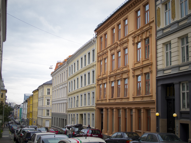
English: The building facade of Markveien 3-5. These buildings from 1890's is located on Grünerløkka, Oslo. They are part of the conservated area of Birkelunden. Photographed in September 2012. |
|
Date | ||
Source | Own work | |
Author | Tore Sætre | |
Permission (Reusing this file) |
|
This is a photo of a monument in Norway, number: 98274 in the Norwegian Directorate for Cultural Heritage database.
|
This is a photo of a monument in Norway, number: 98280 in the Norwegian Directorate for Cultural Heritage database.
|
This is a photo of a monument in Norway, number: 98253 in the Norwegian Directorate for Cultural Heritage database.
|
This image was uploaded as part of Wiki Loves Monuments 2012.
Afrikaans ∙ Alemannisch ∙ azərbaycanca ∙ Bahasa Indonesia ∙ Bahasa Melayu ∙ Bikol Central ∙ bosanski ∙ brezhoneg ∙ català ∙ čeština ∙ Cymraeg ∙ dansk ∙ davvisámegiella ∙ Deutsch ∙ eesti ∙ English ∙ español ∙ Esperanto ∙ euskara ∙ français ∙ Frysk ∙ Gaeilge ∙ galego ∙ hrvatski ∙ Ido ∙ italiano ∙ latviešu ∙ Lëtzebuergesch ∙ Malagasy ∙ magyar ∙ Malti ∙ Nederlands ∙ norsk ∙ norsk nynorsk ∙ norsk bokmål ∙ polski ∙ português ∙ português do Brasil ∙ română ∙ shqip ∙ sicilianu ∙ slovenčina ∙ slovenščina ∙ suomi ∙ svenska ∙ Tagalog ∙ Türkçe ∙ Yorùbá ∙ Zazaki ∙ Ελληνικά ∙ беларуская ∙ беларуская (тарашкевіца) ∙ български ∙ кыргызча ∙ македонски ∙ русский ∙ српски / srpski ∙ українська ∙ ქართული ∙ հայերեն ∙ नेपाली ∙ हिन्दी ∙ বাংলা ∙ മലയാളം ∙ ไทย ∙ 한국어 ∙ +/− |
Licensing[edit]
- You are free:
- to share – to copy, distribute and transmit the work
- to remix – to adapt the work
- Under the following conditions:
- attribution – You must give appropriate credit, provide a link to the license, and indicate if changes were made. You may do so in any reasonable manner, but not in any way that suggests the licensor endorses you or your use.
- share alike – If you remix, transform, or build upon the material, you must distribute your contributions under the same or compatible license as the original.
File history
Click on a date/time to view the file as it appeared at that time.
Date/Time | Thumbnail | Dimensions | User | Comment | |
---|---|---|---|---|---|
current | 18:21, 10 September 2012 | 640 × 480 (218 KB) | Toresetre (talk | contribs) | User created page with UploadWizard |
You cannot overwrite this file.
File usage on Commons
The following 2 pages use this file:
Metadata
This file contains additional information such as Exif metadata which may have been added by the digital camera, scanner, or software program used to create or digitize it. If the file has been modified from its original state, some details such as the timestamp may not fully reflect those of the original file. The timestamp is only as accurate as the clock in the camera, and it may be completely wrong.
Image title |
|
---|---|
Author | Tore Saetre |
Copyright holder |
|
Date and time of data generation | 16:57, 9 September 2012 |
Latitude | 59° 55′ 37.91″ N |
Longitude | 10° 45′ 25.54″ E |
Altitude | 99.1 meters above sea level |
Online copyright statement | www.setre.net |
Short title |
|
Usage terms |
|
City shown | Oslo |
Horizontal resolution | 72 dpi |
Vertical resolution | 72 dpi |
Software used | Adobe Photoshop Lightroom 4.1 (Windows) |
File change date and time | 19:30, 10 September 2012 |
Exif version | 2.3 |
Date and time of digitizing | 16:57, 9 September 2012 |
Unique image ID | 9fa75b66b3b45f9b19f24540494ff6f0 |
GPS tag version | 0.0.2.2 |
Date metadata was last modified | 21:28, 10 September 2012 |
Unique ID of original document | 4F149A4F9A3761592C91D36C255DDD77 |
Keywords |
|
Contact information | tore@setre.net
www.setre.net
|
Province or state shown | Oslo |
Country shown | Norway |
Sublocation of city shown | Grünerløkka |
IIM version | 4 |
Structured data
Items portrayed in this file
depicts
9 September 2012
59°55'37.90801"N, 10°45'25.54200"E
- Files by User:Toresetre
- Cultural heritage monuments in Norway with known IDs
- Images from Wiki Loves Monuments 2012
- Images from Wiki Loves Monuments 2012 in Norway
- CC-BY-SA-4.0
- Self-published work
- Taken with Canon PowerShot G12
- 2012 photographs by Tore Sætre
- Norway photographs taken on 2012-09-09
- Pages with maps