File:Marmagne (Côte-d'Or) (9257653278).jpg

Original file (4,928 × 3,264 pixels, file size: 10.11 MB, MIME type: image/jpeg)
Captions
Captions
Summary[edit]
_(9257653278).jpg&action=edit§ion=1)
| Description |
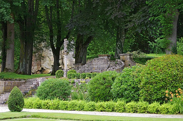
L'abbaye de Fontenay. Abbaye cistercienne de Fontenay Fondée en 1119 par saint Bernard, l'abbaye bourguignonne de Fontenay, à l'architecture dépouillée, avec son église, son cloître, son réfectoire, son dortoir, sa boulangerie et sa forge, illustre bien l'idéal d'autarcie des premières communautés de moines cisterciens. Cistercian Abbey of Fontenay This stark Burgundian monastery was founded by St Bernard in 1119. With its church, cloister, refectory, sleeping quarters, bakery and ironworks, it is an excellent illustration of the ideal of self-sufficiency as practised by the earliest communities of Cistercian monks. دير فونتوناي الكسترسي إنّ دير فونتوناي البرغونيّ الذي أسسه القديس برنار عام 1119 بهندسته غير المزخرفة، وكنيسته ورواقه وقاعة طعامه ودار منامته ومخبزه ومصهر الحديد الخاص به، يجسد كلّ التجسيد نموذج الاكتفاء الذاتي للمجتمعات الأولية التي شكّلها الرهبان الكسترسيون. 丰特莱的西斯特尔教团修道院 这座刻板的勃艮第修道院由圣伯纳尔(St Bernard)修建于1119年,修道院的教堂、回廊、餐厅、住宿区、面包房和钢铁厂一起,完美诠释了早期西斯特尔教团修道士自给自足的理想。 Цистерцианский монастырь Фонтене Этот внушительный бургундский монастырь был основан в 1119 г. Св. Бернаром. Все постройки монастыря - церковь, клостер, трапезная, жилые кельи, пекарня и кузница – прекрасная иллюстрация того идеального натурального хозяйства, к которому стремились ранние общины цистерцианских монахов. Abadía cisterciense de Fontenay Fundado en 1119 por San Bernardo, este monasterio borgoñón de arquitectura austera ilustra perfectamente con sus diferentes componentes –iglesia, claustro, refectorio, dormitorio, panadería y herrería– el ideal de autarquía de las primeras comunidades monásticas cistercienses. Source: UNESCO/ERI |
| Date | Taken on 4 July 2013, 15:52 |
| Source | Marmagne (Côte-d'Or) |
| Author | Daniel Jolivet |
| Camera location | | View this and other nearby images on: OpenStreetMap |
|---|
_(9257653278).jpg¶ms=047.640294_N_0004.389295_E_globe:Earth_type:camera_source:Flickr_&language=en)
Licensing[edit]
_(9257653278).jpg&action=edit§ion=2)
- You are free:
- to share – to copy, distribute and transmit the work
- to remix – to adapt the work
- Under the following conditions:
- attribution – You must give appropriate credit, provide a link to the license, and indicate if changes were made. You may do so in any reasonable manner, but not in any way that suggests the licensor endorses you or your use.
| This image was originally posted to Flickr by sybarite48 at https://flickr.com/photos/26082117@N07/9257653278 (archive). It was reviewed on 22 January 2018 by FlickreviewR 2 and was confirmed to be licensed under the terms of the cc-by-2.0. |
File history
Click on a date/time to view the file as it appeared at that time.
| Date/Time | Thumbnail | Dimensions | User | Comment | |
|---|---|---|---|---|---|
| current | 09:31, 22 January 2018 | | 4,928 × 3,264 (10.11 MB) | Thesupermat2 (talk | contribs) | Transferred from Flickr via Flickr2Commons |
You cannot overwrite this file.
File usage on Commons
There are no pages that use this file.
_(9257653278).jpg&oldid=783453427)