File:Marquesas Islands location map.svg
跳至導覽
跳至搜尋

此 SVG 檔案的 PNG 預覽的大小:515 × 600 像素。 其他解析度:206 × 240 像素 | 412 × 480 像素 | 659 × 768 像素 | 879 × 1,024 像素 | 1,758 × 2,048 像素 | 898 × 1,046 像素。
原始檔案 (SVG 檔案,表面大小:898 × 1,046 像素,檔案大小:15 KB)
說明
說明
添加單行說明來描述出檔案所代表的內容
| 描述 |
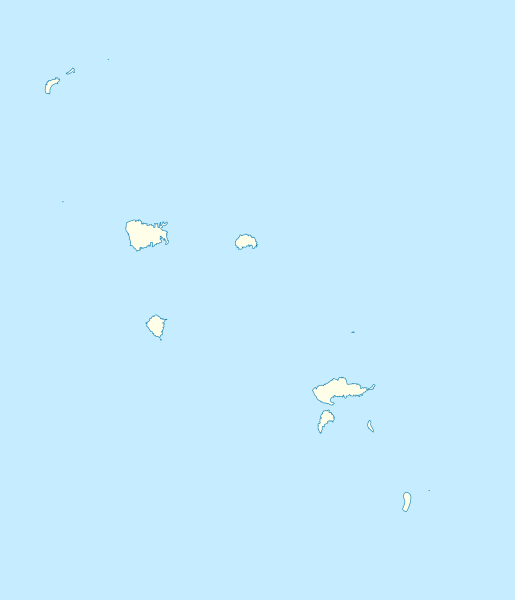
Quadratische Plattkarte. Geographische Begrenzung der Karte:
Equirectangular projection. Geographic limits of the map:
|
| 日期 | (UTC) |
| 來源 | |
| 作者 |
|
我,本作品的著作權持有者,決定用以下授權條款發佈本作品:

|
已授權您依據自由軟體基金會發行的無固定段落、封面文字和封底文字GNU自由文件授權條款1.2版或任意後續版本,對本檔進行複製、傳播和/或修改。該協議的副本列在GNU自由文件授權條款中。 |
您可以選擇您需要的授權條款。
原始上傳日誌
[編輯]
This image is a derivative work of the following images:
- File:French_Polynesia_relief_map.svg licensed with Cc-by-sa-3.0,2.5,2.0,1.0, GFDL
- 2008-10-16T20:29:12Z Sardon 1260x1260 (1472354 Bytes) {{Information |Description={{en|1=Topographic map with French names of French Polynesia}} {{fr|1=Carte topographique de la Polynésie française, en français}} |Source=Own work.{{clr}} Data sources : * Background map : [http
Uploaded with derivativeFX
檔案歷史
點選日期/時間以檢視該時間的檔案版本。
| 日期/時間 | 縮圖 | 尺寸 | 使用者 | 備註 | |
|---|---|---|---|---|---|
| 目前 | 2010年9月3日 (五) 17:48 | | 898 × 1,046(15 KB) | NordNordWest(留言 | 貢獻) | c |
| 2010年9月3日 (五) 17:34 |  | 898 × 1,046(17 KB) | NordNordWest(留言 | 貢獻) | c | |
| 2010年9月3日 (五) 17:30 |  | 898 × 1,046(46 KB) | NordNordWest(留言 | 貢獻) | {{Information |Description={{de|Positionskarte der Marquesas-Inseln, Französisch-Polynesien}} Quadratische Plattkarte. Geographische Begrenzung der Karte: * N: 7.5° S * S: 11° S * W: 141° W * O: 138° |
無法覆蓋此檔案。
檔案用途
下列頁面有用到此檔案:
全域檔案使用狀況
以下其他 wiki 使用了這個檔案:
- ba.wikipedia.org 的使用狀況
- cs.wikipedia.org 的使用狀況
- de.wikipedia.org 的使用狀況
- Hiva Oa
- Hatutu
- Motu Nao
- Fatu Hiva
- Nuku Hiva
- Ua Pou
- Motu One (Marquesas)
- Eiao
- Ua Huka
- Motu Iti (Marquesas)
- Tahuata
- Fatu Huku
- Wikipedia:Kartenwerkstatt/Positionskarten/Australien und Ozeanien
- Mont Temetiu
- Mont Oave
- Vorlage:Positionskarte Französisch-Polynesien Marquesas
- Mont Tekao
- Mohotane
- Terihi
- Haʻava
- en.wikipedia.org 的使用狀況
- fa.wikipedia.org 的使用狀況
- fr.wikipedia.org 的使用狀況
- he.wikipedia.org 的使用狀況
檢視此檔案的更多全域使用狀況。