File:Marsrover Perseverance Mastcam-Z Sol 1041 (53500259497).jpg
Jump to navigation
Jump to search

Size of this preview: 800 × 158 pixels. Other resolutions: 320 × 63 pixels | 640 × 126 pixels | 1,024 × 202 pixels | 1,280 × 253 pixels | 2,560 × 505 pixels | 10,668 × 2,106 pixels.
Original file (10,668 × 2,106 pixels, file size: 5.65 MB, MIME type: image/jpeg)
Captions
Captions
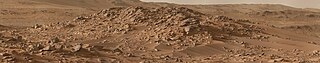
View up Neretva Vallis captured by the Right Mastcam-Z on Perseverance during the evening of Sol 1041. The image was calibrated to approximately match the colors the adjusted human eye would see on Mars. .
Summary
[edit].jpg&action=edit§ion=1)
| Description |
English: View up Neretva Vallis captured by the Right Mastcam-Z on Perseverance during the evening of Sol 1041.
The image was calibrated to approximately match the colors the adjusted human eye would see on Mars. Credit: NASA/ JPL-Caltech / ASU/ Simeon Schmauß |
| Date | Taken on 24 January 2024, 11:42:14 |
| Source | Marsrover Perseverance Mastcam-Z Sol 1041 |
| Author | semeion.photo |
| Flickr set | Perseverance |
| Flickr tags | mars2020; nasa; mars; perseverance |
| Object location | | View this and other nearby images on: OpenStreetMap |
|---|
.jpg¶ms=018.000000_N_0077.000000_E_globe:Earth_class:object_type:object__&language=en)
Licensing
[edit].jpg&action=edit§ion=2)
This file is licensed under the Creative Commons Attribution-Share Alike 2.0 Generic license.
- You are free:
- to share – to copy, distribute and transmit the work
- to remix – to adapt the work
- Under the following conditions:
- attribution – You must give appropriate credit, provide a link to the license, and indicate if changes were made. You may do so in any reasonable manner, but not in any way that suggests the licensor endorses you or your use.
- share alike – If you remix, transform, or build upon the material, you must distribute your contributions under the same or compatible license as the original.
| This image was originally posted to Flickr by semeion.photo at https://flickr.com/photos/193178812@N02/53500259497. It was reviewed on 1 February 2024 by FlickreviewR 2 and was confirmed to be licensed under the terms of the cc-by-sa-2.0. |
File history
Click on a date/time to view the file as it appeared at that time.
| Date/Time | Thumbnail | Dimensions | User | Comment | |
|---|---|---|---|---|---|
| current | 11:01, 1 February 2024 | 10,668 × 2,106 (5.65 MB) | OptimusPrimeBot (talk | contribs) | #Spacemedia - Upload of https://live.staticflickr.com/65535/53500259497_c0935c9624_o.jpg via Commons:Spacemedia |
You cannot overwrite this file.
File usage on Commons
There are no pages that use this file.
.jpg&oldid=847927330)