File:Martin, R.M.; Tallis, J. & F.; 1851 Malay Archipelago, Or East India Islands (cropped).png
Jump to navigation
Jump to search

Size of this preview: 432 × 600 pixels. Other resolutions: 173 × 240 pixels | 500 × 694 pixels.
Original file (500 × 694 pixels, file size: 748 KB, MIME type: image/png)
Captions
Captions
Add a one-line explanation of what this file represents
Summary
[edit].png&action=edit§ion=1)
| Description |
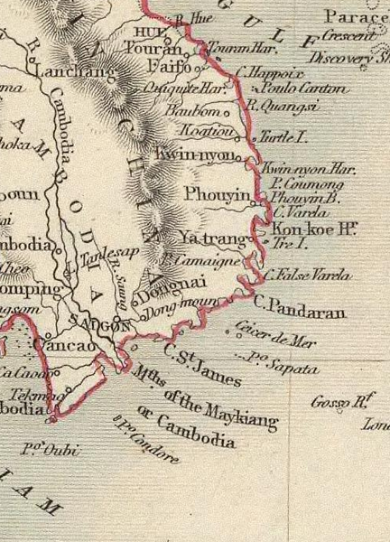
English: Cropped version of Martin, R.M.; J. & F. Tallis' 1851 map of the East Indies, showing Cape de Pandarang (Phan Rang) of old Panduranga. |
| Date | 02:01, 2 November 2021 |
| Source | |
| Author | Part of the map of the East India Isles by J. Rapkin, Martin R.M, and John Tallis, published in 1851 at New York. (see complete version below) |
| Other versions |
Complete map  |
Licensing
[edit].png&action=edit§ion=2)

|
Permission is granted to copy, distribute and/or modify this document under the terms of the GNU Free Documentation License, Version 1.2 or any later version published by the Free Software Foundation; with no Invariant Sections, no Front-Cover Texts, and no Back-Cover Texts. A copy of the license is included in the section entitled GNU Free Documentation License. |
| This file is licensed under the Creative Commons Attribution-Share Alike 3.0 Unported license. | ||
| ||
| This licensing tag was added to this file as part of the GFDL licensing update. |
File history
Click on a date/time to view the file as it appeared at that time.
| Date/Time | Thumbnail | Dimensions | User | Comment | |
|---|---|---|---|---|---|
| current | 18:23, 25 May 2022 | | 500 × 694 (748 KB) | Laska666 (talk | contribs) | Uploaded own work with UploadWizard |
You cannot overwrite this file.
File usage on Commons
There are no pages that use this file.
.png&oldid=914900563)