File:Martin Waldseemüller, Tabv. Terre Sanctae 02-copy-2 (FL37483984 3607368).jpg
Jump to navigation
Jump to search

Size of this preview: 800 × 597 pixels. Other resolutions: 320 × 239 pixels | 640 × 477 pixels | 1,024 × 764 pixels | 1,280 × 955 pixels | 2,560 × 1,910 pixels | 12,780 × 9,533 pixels.
Original file (12,780 × 9,533 pixels, file size: 56.82 MB, MIME type: image/jpeg)
Captions
Captions
Add a one-line explanation of what this file represents
Summary[edit]
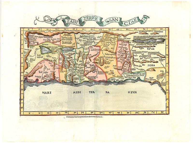
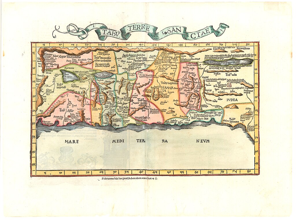
| Martin Waldseemüller: Tabv. Terre Sanctae
( |
||||||||||||||||||||||||
|---|---|---|---|---|---|---|---|---|---|---|---|---|---|---|---|---|---|---|---|---|---|---|---|---|
| Artist |
| |||||||||||||||||||||||
| Contributors | Ptolemy, active 2nd century Vesconte, Petrus Sanudo, Marino, approximately 1260-1343 | |||||||||||||||||||||||
| Title |
Tabv. Terre Sanctae |
|||||||||||||||||||||||
| Publisher |
Laurent Fries |
|||||||||||||||||||||||
| Description |
Tabv. Terre Sanctae. |
|||||||||||||||||||||||
| Language | Latin | |||||||||||||||||||||||
| Publication date | 1525 | |||||||||||||||||||||||
| Medium | 1 sheet ; | |||||||||||||||||||||||
| Dimensions | height: 36 cm (14.1 in); width: 49 cm (19.2 in) | |||||||||||||||||||||||
| Collection |
|
|||||||||||||||||||||||
| Current location |
|
|||||||||||||||||||||||
| Place of publication | Strasbourg | |||||||||||||||||||||||
| search Merhav catalog | Strasbourg | |||||||||||||||||||||||
| Notes | Woodcut .; From: Geographia by Ptolemy.; Latin text on verso.; Drawn after the first modern sketch of the Holy Land made by Marino Sanuto and Pietro Vesconte in 1320. | |||||||||||||||||||||||
| IE PID | IE37483982 | |||||||||||||||||||||||
| Rosetta filename | FL37483984 | |||||||||||||||||||||||
| NNL item ID (P3959) | 990036073680205171 | |||||||||||||||||||||||
| search Merhav catalog | Latin, Martin Waldseemüller | |||||||||||||||||||||||
| search Merhav catalog | Terre SanctaeLaurent Fries | |||||||||||||||||||||||
| Source/Photographer |
|
|||||||||||||||||||||||
| Other versions | ||||||||||||||||||||||||
| Jpg / Tif version |
|
|||||||||||||||||||||||


.jpg)

.jpg&action=edit§ion=1)
Licensing[edit]
.jpg&action=edit§ion=2)
The copyright situation of this work is theoretically uncertain, because in the country of origin copyright lasts 70 years after the death of the author, and the date of the author's death is unknown. However, the date of creation of the work was over 120 years ago, and it is thus a reasonable assumption that the copyright has expired (see here for the community discussion). Do not use this template if the date of death of the author is known.
| |
| This file has been identified as being free of known restrictions under copyright law, including all related and neighboring rights. | |
File history
Click on a date/time to view the file as it appeared at that time.
| Date/Time | Thumbnail | Dimensions | User | Comment | |
|---|---|---|---|---|---|
| current | 02:05, 2 September 2023 | | 12,780 × 9,533 (56.82 MB) | Geagea (talk | contribs) | pattypan 22.03 |
You cannot overwrite this file.
File usage on Commons
The following page uses this file:
.jpg&oldid=850963639)