File:Masirah 76.jpg
Naviqasiyaya keç
Axtarışa keç
Daha yüksək versiyası yoxdur.
Masirah_76.jpg (426 × 354 piksel, fayl həcmi: 37 KB, MIME növü: image/jpeg)
Captions
Captions
Add a one-line explanation of what this file represents
Xülasə
[redaktə]
| İzah |
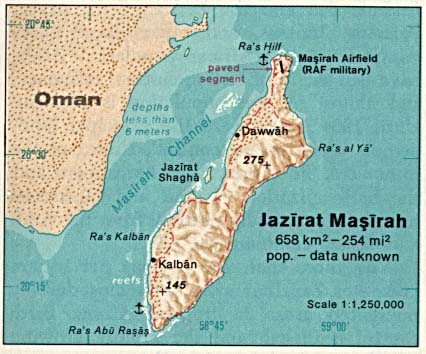
English: Map of Masirah Island (Oman) in the Indian Ocean |
| Tarix | |
| Mənbə | http://www.lib.utexas.edu/maps/islands_oceans_poles/jazirat_masirah.jpg |
| Müəllif | Taken from Perry-Castañeda Library (PCL), originally from CIA Indian Ocean Atlas |
Lisenziya
[redaktə]
| This image is a work of a Central Intelligence Agency employee, taken or made as part of that person's official duties. As a Work of the United States Government, this image or media is in the public domain in the United States.
|

|
Faylın tarixçəsi
Faylın əvvəlki versiyasını görmək üçün gün/tarix bölməsindəki tarixlərə klikləyin.
| Tarix/Vaxt | Miniatür | Ölçülər | İstifadəçi | Şərh | |
|---|---|---|---|---|---|
| hal-hazırkı | 11:42, 23 iyul 2009 | | 426 × 354 (37 KB) | Telim tor (müzakirə | töhfələr) | == Information == {{Information |Description= {{en|Map of Mariah Island (Oman) in the Indian Ocean}} |Source=http://www.lib.utexas.edu/maps/islands_oceans_poles/jazirat_masirah.jpg |Date=1976 |Author=Taken from Perry-Castañeda Library (PCL), originally f |
Siz bu faylı yenidən yükləyə bilməzsiniz.
Faylın istifadəsi
Aşağıdakı səhifə bu faylı istifadə edir:
Faylın qlobal istifadəsi
Bu fayl aşağıdakı vikilərdə istifadə olunur:
- ar.wikipedia.org layihəsində istifadəsi
- arz.wikipedia.org layihəsində istifadəsi
- az.wikipedia.org layihəsində istifadəsi
- ca.wikipedia.org layihəsində istifadəsi
- cs.wikipedia.org layihəsində istifadəsi
- de.wikipedia.org layihəsində istifadəsi
- en.wikipedia.org layihəsində istifadəsi
- es.wikipedia.org layihəsində istifadəsi
- eu.wikipedia.org layihəsində istifadəsi
- fa.wikipedia.org layihəsində istifadəsi
- fi.wikipedia.org layihəsində istifadəsi
- gl.wikipedia.org layihəsində istifadəsi
- id.wikipedia.org layihəsində istifadəsi
- it.wikipedia.org layihəsində istifadəsi
- nn.wikipedia.org layihəsində istifadəsi
- pl.wikipedia.org layihəsində istifadəsi
- ru.wikipedia.org layihəsində istifadəsi
- tr.wikipedia.org layihəsində istifadəsi
- uk.wikipedia.org layihəsində istifadəsi
- ur.wikipedia.org layihəsində istifadəsi
- www.wikidata.org layihəsində istifadəsi
- zh.wikipedia.org layihəsində istifadəsi