File:MassifAuthion-OpenStreetMap.png
Jump to navigation
Jump to search

Size of this preview: 800 × 510 pixels. Other resolutions: 320 × 204 pixels | 640 × 408 pixels | 1,148 × 732 pixels.
Original file (1,148 × 732 pixels, file size: 936 KB, MIME type: image/png)
Captions
Captions
Add a one-line explanation of what this file represents
Summary
[edit]
| Description |
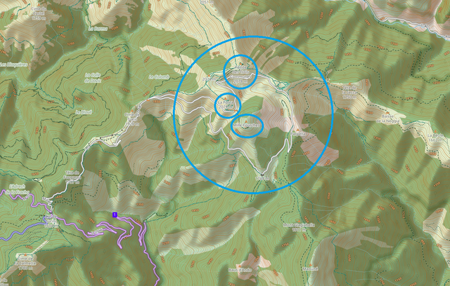
Français : Massif de l'Authion (grand cercle), situé dans les Alpes-Maritimes et ses 3 principaux ouvrages militaires (petits cercles): redoute de la Pointe des trois communes, ouvrage de la Forca, ouvrage des Mille-Fourches. |
| Date | |
| Source | OpenStreetMap |
| Author | OpenStreetMap |
| Camera location | | View this and other nearby images on: OpenStreetMap |
|---|
Licensing
[edit]
This file is licensed under the Creative Commons Attribution-Share Alike 3.0 Unported license.
- You are free:
- to share – to copy, distribute and transmit the work
- to remix – to adapt the work
- Under the following conditions:
- attribution – You must give appropriate credit, provide a link to the license, and indicate if changes were made. You may do so in any reasonable manner, but not in any way that suggests the licensor endorses you or your use.
- share alike – If you remix, transform, or build upon the material, you must distribute your contributions under the same or compatible license as the original.
File history
Click on a date/time to view the file as it appeared at that time.
| Date/Time | Thumbnail | Dimensions | User | Comment | |
|---|---|---|---|---|---|
| current | 20:20, 3 June 2022 | | 1,148 × 732 (936 KB) | JeanClaude06 (talk | contribs) | Uploaded a work by OpenStreetMap from OpenStreetMap with UploadWizard |
You cannot overwrite this file.
File usage on Commons
There are no pages that use this file.
File usage on other wikis
The following other wikis use this file:
- Usage on fr.wikipedia.org