File:McConnell's Mill Covered Bridge northern side in sunlight.jpg
Jump to navigation
Jump to search

Size of this preview: 800 × 600 pixels. Other resolutions: 320 × 240 pixels | 640 × 480 pixels | 1,024 × 768 pixels | 1,280 × 960 pixels | 2,560 × 1,920 pixels | 2,816 × 2,112 pixels.
Original file (2,816 × 2,112 pixels, file size: 3.21 MB, MIME type: image/jpeg)
Captions
Captions
Add a one-line explanation of what this file represents
|
This is an image of a place or building that is listed on the National Register of Historic Places in the United States of America. Its reference number is 80003544. |
| Camera location | | View this and other nearby images on: OpenStreetMap |
|---|
| Description |
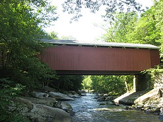
English: Northern side of McConnell's Mill Covered Bridge at McConnells Mill State Park, located in far eastern Slippery Rock Township, Lawrence County, Pennsylvania, United States. Built in 1874, the bridge is listed on the National Register of Historic Places. Picture taken from rocks below the eastern end of the bridge. |
||
| Date | Taken on 16 May 2009 | ||
| Source | Own work | ||
| Author | Nyttend | ||
| Permission (Reusing this file) |
|
||
| Other versions |
 Same view in the shade Same view in the shade |
File history
Click on a date/time to view the file as it appeared at that time.
| Date/Time | Thumbnail | Dimensions | User | Comment | |
|---|---|---|---|---|---|
| current | 16:45, 31 August 2009 | | 2,816 × 2,112 (3.21 MB) | Nyttend (talk | contribs) | {{Location|40|57|10|N|80|10|14|W}} {{Information |Description={{en|Northern side of {{w|McConnell's Mill Covered Bridge}} at {{w|McConnells Mill State Park}}, located in far eastern {{w|Slippery Rock Township, Lawrence County, Pennsylvania|Slippery Rock T |
You cannot overwrite this file.
File usage on Commons
The following page uses this file:
File usage on other wikis
The following other wikis use this file:
- Usage on en.wikipedia.org
- Usage on www.wikidata.org