File:Mehrangarh, Rajasthan.jpg
Jump to navigation
Jump to search

Size of this preview: 661 × 600 pixels. Other resolutions: 265 × 240 pixels | 529 × 480 pixels | 846 × 768 pixels | 1,128 × 1,024 pixels | 1,600 × 1,452 pixels.
Original file (1,600 × 1,452 pixels, file size: 1.15 MB, MIME type: image/jpeg)
Captions
Captions
Add a one-line explanation of what this file represents
Summary
[edit]
| Description |
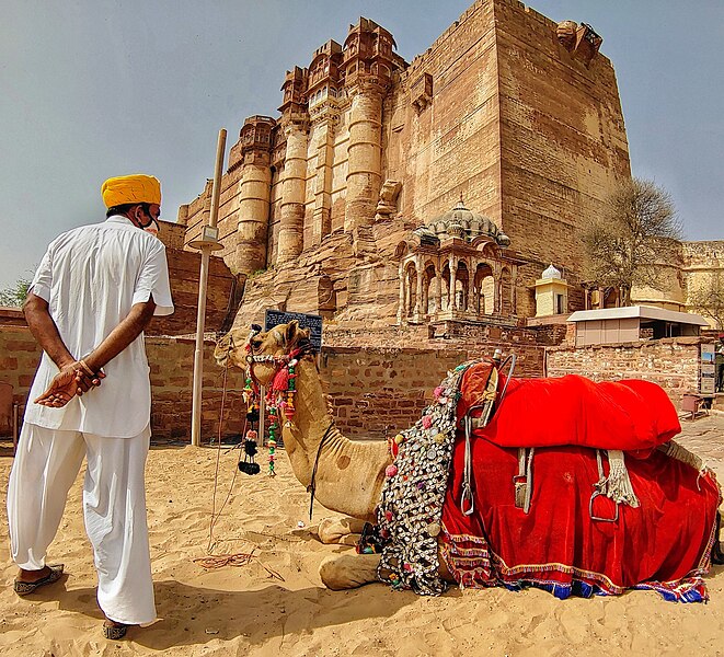
English: A Man, wearing a mask, watching his camel in front of Mehrangarh Fort, hoping for things to get back on track as Tourism was the worst hit sector due to Covid19 Pandemic.
Mehrangarh Fort is an architectural wonder, besides being associated with a diverse history and cultural heritage. The fort is considered one of the breathtaking forts in the state of Rajasthan. Mehrangarh castle, situated in Jodhpur, be probably the biggest fort in India. Work was done here Rao Jodha route around 1459, and arrangements have been made to strengthen the city at a distance of 410 feet. Surrounded by its boundaries, some of the present-day castles have remote locations to acknowledge their unexpected desire. A zig-zag signifies as the city begins to descend. On one side of the stronghold is the Ketri Singh Soda Umbrella, a warrior that knocks it over the safety of Mehrangarh. The name of the Mehrangarh fort is derived Mehr-Garh: Mehr means the sun and Garh mean fort. Mehr-Garh came to be known as Mehrangarh due to the pronunciation of the local language.
|
||||
| Date | |||||
| Source | Own work | ||||
| Author | Aman Malhotra |
| Camera location | | View this and other nearby images on: OpenStreetMap |
|---|
Licensing
[edit]
I, the copyright holder of this work, hereby publish it under the following license:
This file is licensed under the Creative Commons Attribution-Share Alike 4.0 International license.
- You are free:
- to share – to copy, distribute and transmit the work
- to remix – to adapt the work
- Under the following conditions:
- attribution – You must give appropriate credit, provide a link to the license, and indicate if changes were made. You may do so in any reasonable manner, but not in any way that suggests the licensor endorses you or your use.
- share alike – If you remix, transform, or build upon the material, you must distribute your contributions under the same or compatible license as the original.

|
This image was uploaded as part of Wiki Loves Monuments 2021.
|
 |
File history
Click on a date/time to view the file as it appeared at that time.
| Date/Time | Thumbnail | Dimensions | User | Comment | |
|---|---|---|---|---|---|
| current | 11:43, 12 September 2021 | | 1,600 × 1,452 (1.15 MB) | Malhotraaman1604 (talk | contribs) | Uploaded own work with UploadWizard |
You cannot overwrite this file.
File usage on Commons
There are no pages that use this file.