File:Mercator north pole 1595.jpg
跳至導覽
跳至搜尋
預覽大小:635 × 600 像素。 其他解析度:254 × 240 像素 | 508 × 480 像素 | 813 × 768 像素 | 1,084 × 1,024 像素 | 1,700 × 1,606 像素。
原始檔案 (1,700 × 1,606 像素,檔案大小:1.13 MB,MIME 類型:image/jpeg)
說明
說明
添加單行說明來描述出檔案所代表的內容
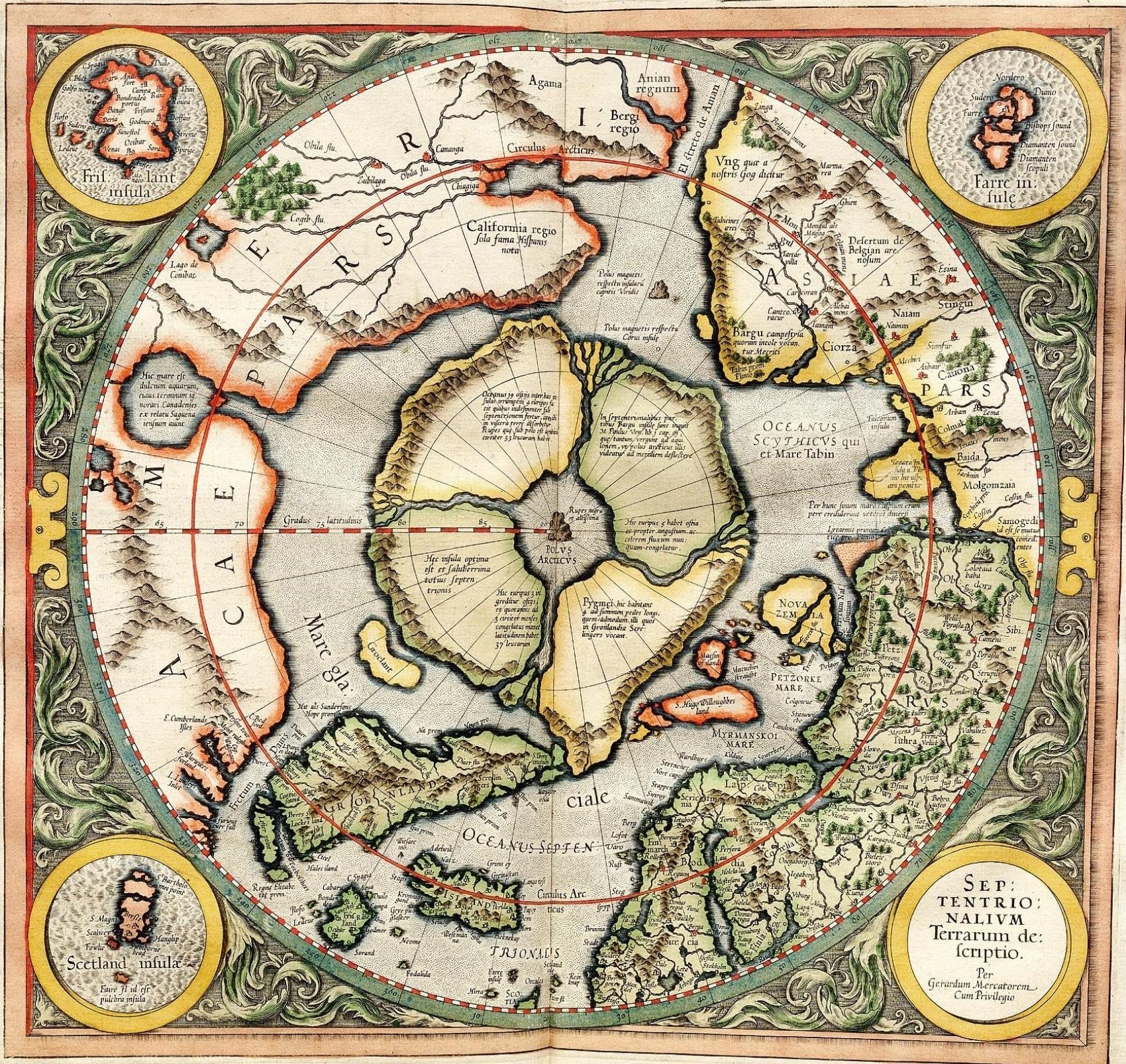
Mercator's 1595 map of the Arctic
摘要[編輯]
| 描述 |
Mercator's 1595 map of the Arctic. Mercator, Gerhard, 1512-1594. "Septentrionalium Terrarum descriptio" [1595]. First state, from his posthumously published atlas, Atlantis pars altera. |
||||||||||||||||||||||||||
| 日期 | |||||||||||||||||||||||||||
| 來源 | http://libweb5.princeton.edu/visual_materials/maps/websites/northwest-passage/mercator.htm | ||||||||||||||||||||||||||
| 作者 |
|
||||||||||||||||||||||||||
| 授權許可 (重用此檔案) |
|
||||||||||||||||||||||||||

授權條款[編輯]
|
本作品在其來源國以及其他版權期限是作者逝世後100年或以下的國家與地區屬於公有領域。 | |
| 此作品無已知的著作權限制,亦不受所有相關和鄰接的權利限制。 | |
_-_Geographicus_-_NorthPole-mercator-1606.jpg)
]
檔案歷史
點選日期/時間以檢視該時間的檔案版本。
| 日期/時間 | 縮圖 | 尺寸 | 用戶 | 備註 | |
|---|---|---|---|---|---|
| 目前 | 2008年3月14日 (五) 11:32 | | 1,700 × 1,606(1.13 MB) | Pallidio~commonswiki(對話 | 貢獻) | {{Information |Description= |Source= |Date= |Author= |Permission= |other_versions= }} Maps made in the 16th century | Gerardus Mercator | Maps by Gerardus Mercator | 1595 | Old maps of the world | |
無法覆蓋此檔案。
檔案用途
下列3個頁面有用到此檔案:
全域檔案使用狀況
以下其他 wiki 使用了這個檔案:
- ba.wikipedia.org 的使用狀況
- be-tarask.wikipedia.org 的使用狀況
- be.wikipedia.org 的使用狀況
- de.wikipedia.org 的使用狀況
- en.wikipedia.org 的使用狀況
- eo.wikipedia.org 的使用狀況
- es.wikipedia.org 的使用狀況
- fr.wikipedia.org 的使用狀況
- hy.wikipedia.org 的使用狀況
- it.wikipedia.org 的使用狀況
- ja.wikipedia.org 的使用狀況
- ka.wikipedia.org 的使用狀況
- la.wikipedia.org 的使用狀況
- nl.wikipedia.org 的使用狀況
- pa.wikipedia.org 的使用狀況
- pl.wikipedia.org 的使用狀況
- ru.wikipedia.org 的使用狀況
- sv.wikipedia.org 的使用狀況
- te.wikipedia.org 的使用狀況
- te.wiktionary.org 的使用狀況
- tt.wikipedia.org 的使用狀況
- zh.wikipedia.org 的使用狀況