File:Metro, suburban train and tramway map of Algiers.png
Aller à la navigation
Aller à la recherche
Taille de cet aperçu : 800 × 494 pixels. Autres résolutions : 320 × 197 pixels | 640 × 395 pixels | 1 024 × 632 pixels | 1 280 × 790 pixels | 2 560 × 1 579 pixels | 5 192 × 3 203 pixels.
Fichier d’origine (5 192 × 3 203 pixels, taille du fichier : 7,89 Mio, type MIME : image/png)
Légendes
Légendes
Ajoutez en une ligne la description de ce que représente ce fichier
| Description |
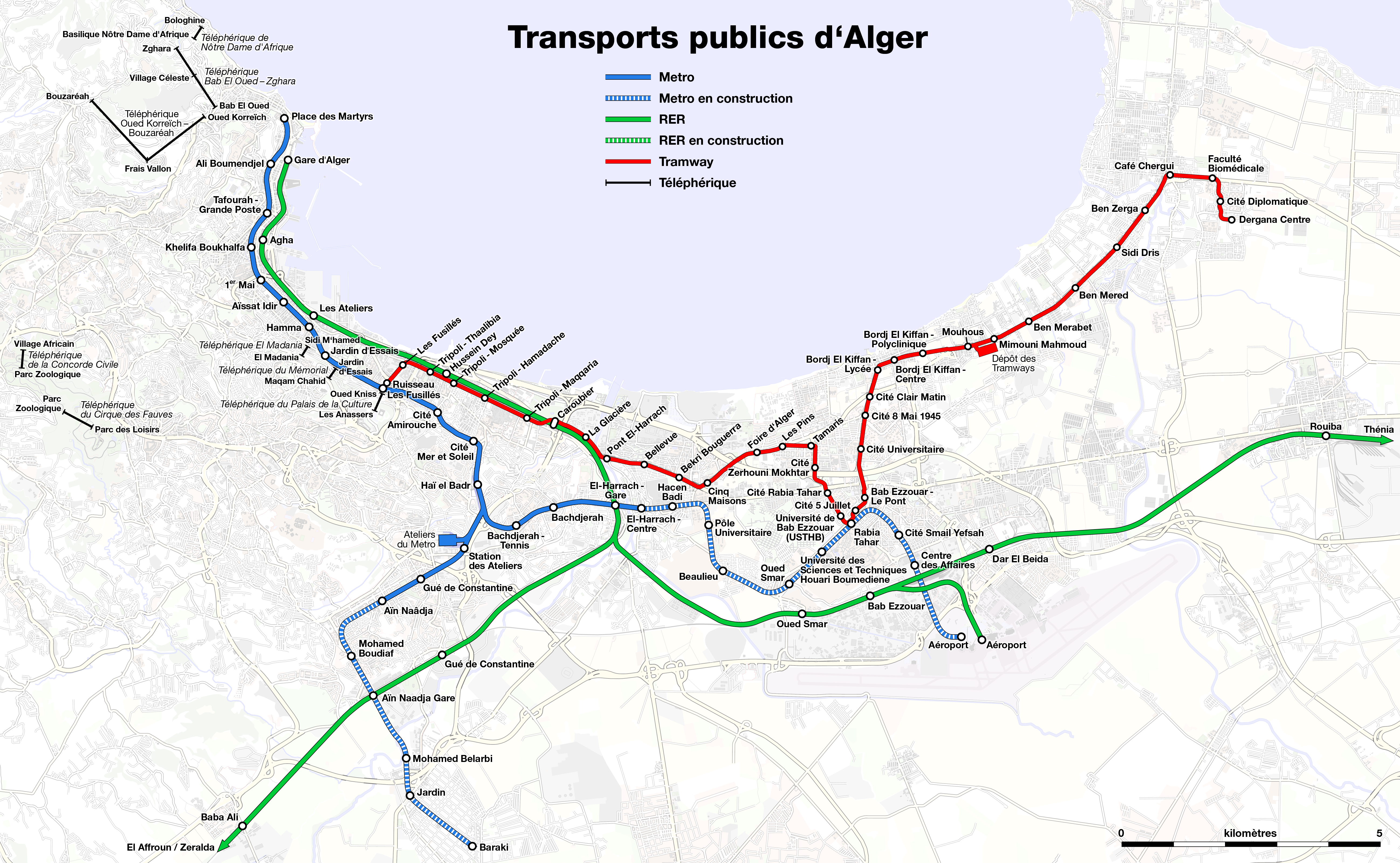
العربية: خريطة المترو، قطار الضواحي و ترامواي الجزائر العاصمة
Deutsch: Karte der Metro, S-Bahn und Straßenbahn von Algier
English: Metro, suburban train and tramway map of Algiers
Français : Plan du métro, RER et tramway d'Alger |
| Date | see file history |
| Source | Travail personnel, using OpenStreetMap data for the background |
| Auteur | Maximilian Dörrbecker (Chumwa) |
| Autorisation (Réutilisation de ce fichier) |
All OpenStreetMap data and maps are Creative Commons "CC-BY-SA 2.0" licensed Ce fichier est disponible selon les termes de la licence Creative Commons Attribution – Partage dans les Mêmes Conditions 2.0 Générique
|

|
Cette image (de type transport map) devrait être recréée dans un format vectoriel, en tant que fichier SVG. Cela offrirait plusieurs avantages : voir Commons:Media for cleanup pour plus d'informations. Si une version SVG de cette image est déjà disponible, merci de bien vouloir l'envoyer. Après cela, remplacez ce modèle par {{vector version available|nouveau nom d'image.svg}}.
|
Need Assistance!
I don't live in Algiers and the map basically was drawn after some informations from the Web which are often incorrect or very inaccurate. So if you want the network map as accurate as possible too, please announce your error hints and corrections on my German discussion page.
Thank you!
Historique du fichier
Cliquer sur une date et heure pour voir le fichier tel qu'il était à ce moment-là.
| Date et heure | Vignette | Dimensions | Utilisateur | Commentaire | |
|---|---|---|---|---|---|
| actuel | 13 juin 2020 à 07:34 | | 5 192 × 3 203 (7,89 Mio) | Chumwa (d | contributions) | update |
| 7 juillet 2019 à 05:22 |  | 3 682 × 2 272 (4,84 Mio) | Chumwa (d | contributions) | update, corr | |
| 29 mai 2016 à 07:25 |  | 3 682 × 2 272 (4,85 Mio) | Chumwa (d | contributions) | update | |
| 29 mai 2016 à 05:33 |  | 3 682 × 2 272 (4,83 Mio) | Chumwa (d | contributions) | corr | |
| 28 mai 2016 à 18:19 |  | 3 682 × 2 272 (4,83 Mio) | Chumwa (d | contributions) | update | |
| 27 mai 2016 à 16:39 |  | 5 519 × 3 327 (8,06 Mio) | Chumwa (d | contributions) | update | |
| 15 juin 2010 à 21:47 |  | 2 917 × 2 194 (1,75 Mio) | Chumwa (d | contributions) | update | |
| 9 janvier 2010 à 18:39 |  | 2 917 × 2 194 (1,7 Mio) | Chumwa (d | contributions) | {{Information |Description={{de|Karte der Metro, S-Bahn und Straßenbahn von Algier}} {{en|Metro, suburban train and tramway map of Algiers}} {{fr|Plan du métro, RER et tramway d'Alger}} |Author=Maximilian Dörrbecker ([[:de:User:Chu |
Vous ne pouvez pas remplacer ce fichier.
Utilisations locales du fichier
Les 13 pages suivantes utilisent ce fichier :
- Top 200 transport map images that should use vector graphics
- User:Chumwa/Gallery
- User:Chumwa/OgreBot/Potential transport maps/2016 May 21-31
- User:Chumwa/OgreBot/Potential transport maps/2019 July 1-10
- User:Chumwa/OgreBot/Public transport information/2016 May 21-31
- User:Chumwa/OgreBot/Public transport information/2019 July 1-10
- User:Chumwa/OgreBot/Public transport information/2020 June 11-20
- User:Chumwa/OgreBot/Transport Maps/2016 May 21-31
- User:Chumwa/OgreBot/Transport Maps/2019 July 1-10
- User:Chumwa/OgreBot/Transport Maps/2020 June 11-20
- User:Chumwa/OgreBot/Travel and communication maps/2016 May 21-31
- User:Chumwa/OgreBot/Travel and communication maps/2019 July 1-10
- Category:Trams in Algiers
Utilisations du fichier sur d’autres wikis
Les autres wikis suivants utilisent ce fichier :
- Utilisation sur ar.wikipedia.org
- ولاية الجزائر
- ترامواي الجزائر
- ساحة الشهداء (الجزائر)
- ويكيبيديا:ورشة الصور/أرشيف 6
- ساحة بور سعيد
- خليج الجزائر
- ويكيبيديا:ورشة الصور/أرشيف 20
- محطة قطار زرالدة
- محطة قطار الجزائر
- محطة قطار الحراش
- محطة قطار الرغاية
- محطة قطار الثنية
- محطة قطار بئر توتة
- محطة قطار دلس
- محطة قطار ذراع الميزان
- محطة قطار آغا
- محطة قطار برج منايل
- محطة قطار خروبة
- محطة قطار تسالة المرجة
- محطة قطار بغلية
- محطة قطار بني منصور
- محطة قطار سوق الحد
- محطة قطار بني عمران
- محطة قطار عمال
- محطة قطار الناصرية
- محطة قطار سي مصطفى
- محطة قطار يسر
- محطة قطار بودواو
- محطة قطار قورصو
- محطة قطار بومرداس
- محطة قطار تيجلابين
- مجموعة حداد
- محطة قطار حسين داي
- محطة قطار الدار البيضاء
- محطة قطار باب الزوار
- محطة قطار وادي السمار
- محطة قطار بابا علي
- محطة قطار جسر قسنطينة
- محطة قطار الرويبة الصناعية
- محطة قطار الرغاية الصناعية
- محطة قطار سيدي عبد الله
- محطة قطار جامعة سيدي عبد الله
- محطة قطار الرويبة سوناكوم
- خط الحراش - الرغاية
- خط القصبة - الحراش
- حي بوسحاقي (الجزائر)
- خط سكة حديد من تيزي وزو إلى الثنية
- النقل في ولاية الجزائر
- السلطة المنظمة للنقل الحضري لولاية الجزائر
- Utilisation sur ast.wikipedia.org
Voir davantage sur l’utilisation globale de ce fichier.