File:Meyers5 Frankfurt Judengasse.png
Jump to navigation
Jump to search
No higher resolution available.
Meyers5_Frankfurt_Judengasse.png (344 × 298 pixels, file size: 40 KB, MIME type: image/png)
Captions
Captions
Add a one-line explanation of what this file represents
| Description |
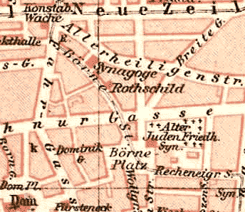
Deutsch: Stadtplan Frankfurt, 1893: Das Gebiet des früheren jüdischen Ghettos wurde 1887 abgerissen. Die Börnestraße entstand auf dem gebogenen Verlauf der früheren Judengasse. Nur die Hauptsynagoge und das Stammhaus der Bankiersfamilie Rothschild blieben erhalten. English: Frankfurt city map, 1893: The medieveal jewish quarter was demolished in 1887. The former Judengasse (Jewish Lane) became the new Börnestraße. Only the old main synagogue and the Rothschild family's house survived the redevelopment. |
| Date | |
| Source |
Deutsch: Meyers Konversationslexikon, 5. Auflage English: Meyers Konversationslexikon, 5.th edition Scan obtained from http://www.hicleones.com/ |
| Author | Unknown, uploaded by Michael König (Magadan) |
| This image comes from the 5th edition of Meyers Konversationslexikon (1893-97). The copyrights have expired and this image is in the public domain. | 
|
This work was published before January 1, 1899 and it is anonymous or pseudonymous due to unknown authorship. It is in the public domain in the United States as well as countries and areas where the copyright terms of anonymous or pseudonymous works are 125 years or fewer since publication.
|
File history
Click on a date/time to view the file as it appeared at that time.
| Date/Time | Thumbnail | Dimensions | User | Comment | |
|---|---|---|---|---|---|
| current | 22:46, 30 September 2005 | | 344 × 298 (40 KB) | Magadan (talk | contribs) | {{User:Magadan/Meyers5 | BESCHR_DE = Stadtplan Frankfurt, 1893: Das Gebiet des früheren jüdischen Ghettos wurde 1887 abgerissen. Die Börnestraße entstand auf dem gebogenen Verlauf der früheren Judengasse. Nur d |
You cannot overwrite this file.
File usage on Commons
The following 2 pages use this file:
File usage on other wikis
The following other wikis use this file:
- Usage on de.wikipedia.org
- Usage on en.wikipedia.org
- Usage on es.wikipedia.org
- Usage on fr.wikipedia.org