File:Middle east graphic 2003.jpg
出自Wikimedia Commons
跳至導覽
跳至搜尋

預覽大小:664 × 600 像素。 其他解析度:266 × 240 像素 | 532 × 480 像素 | 850 × 768 像素 | 1,134 × 1,024 像素 | 2,268 × 2,048 像素 | 2,973 × 2,685 像素。
原始檔案 (2,973 × 2,685 像素,檔案大小:3.91 MB,MIME 類型:image/jpeg)
檔案資訊
結構化資料
說明
說明
添加單行說明來描述出檔案所代表的內容
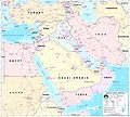
Geographical Map of Middle East
 | 這個file中的所有圖片名上傳在JPEG格式,即使它包含非照片數據。該信息可以以PNG或SVG格式更有效或更準確地存儲。 如果可能,請上傳此圖像的PNG或SVG版本,不含壓縮失真,源自非JPEG源(或移除現存的失真)。完成後,請使用{{Superseded|NewImage.ext}}標記JPEG版本並刪除此標記。此標籤不應應用於照片或掃描件。如需更多信息,請參閱{{BadJPEG}}。 |
摘要
[編輯]Courtesy of the University of Texas Libraries, The University of Texas at Austin http://www.lib.utexas.edu/maps/middle_east.html
High-resolution political / railway / roadmap of the Middle East from 2003.
Further background at http://erg.usgs.gov/nimamaps/.
The map contains several major errors, for example, Haifa, Israel is located where Acre should be, and Tel Aviv is approximately where Netanya should be.
授權條款
[編輯]| Public domainPublic domainfalsefalse |
This image is a work of the United States National Geospatial-Intelligence Agency or one of its predecessor agencies. As a work of the U.S. federal government, the image is in the public domain.
English ∙ српски / srpski ∙ 日本語 ∙ +/− |
 |
檔案歷史
點選日期/時間以檢視該時間的檔案版本。
| 日期/時間 | 縮圖 | 尺寸 | 用戶 | 備註 | |
|---|---|---|---|---|---|
| 目前 | 2012年2月8日 (三) 22:30 |  | 2,973 × 2,685(3.91 MB) | M0tty(對話 | 貢獻) | Remove compression artefacts by a bilateral filtering. |
| 2006年7月14日 (五) 21:43 |  | 2,973 × 2,685(1,013 KB) | Unquietwiki(對話 | 貢獻) | ''Courtesy of the University of Texas Libraries, The University of Texas at Austin'' [http://www.lib.utexas.edu/maps/middle_east.html http://www.lib.utexas.edu/maps/middle_east.html] High-resolution political / railway / roadmap of the Middle East. |
無法覆蓋此檔案。
檔案用途
下列5個頁面有用到此檔案:
全域檔案使用狀況
以下其他 wiki 使用了這個檔案:
- ar.wikipedia.org 的使用狀況
- ويكيبيديا:قوالب/بذور
- ويكيبيديا:قوالب/بذور/جدول بذرة 1
- قالب:بذرة جغرافيا الشرق الأوسط
- بادية الشام
- محافظة العاصمة (البحرين)
- خليج عدن
- دزفول
- زاغروس
- مسجد سليمان
- زاينده
- مسرح أحداث الشرق الأوسط خلال الحرب العالمية الثانية
- الحويزة (مدينة)
- قائمة جزر الخليج العربي
- شرق المتوسط
- قائمة نزاعات الشرق الأوسط الحديثة
- مستخدم:Adnanzoom/مساعدات
- عبد الله بن سعيد
- قرار مجلس الأمن التابع للأمم المتحدة رقم 1381
- مستخدم:ASammour/بذرة-بوابة
- شرف الدين بن الحسن
- فخر الدين بن عدي
- صخر بن صخر بن مسافر
- قالب:بذرة أعلام الشرق الأوسط
- أبجر التاسع
- arz.wikipedia.org 的使用狀況
- ba.wikipedia.org 的使用狀況
- be.wikipedia.org 的使用狀況
- bn.wikipedia.org 的使用狀況
- ca.wikipedia.org 的使用狀況
- ce.wikipedia.org 的使用狀況
- ckb.wikipedia.org 的使用狀況
- el.wikipedia.org 的使用狀況
- en.wikipedia.org 的使用狀況
檢視此檔案的更多全域使用狀況。
詮釋資料
此檔案中包含其他資訊,這些資訊可能是由數位相機或掃描器在建立或數位化過程中所新增的。若檔案自原始狀態已被修改,一些詳細資料可能無法完整反映出已修改的檔案。
| 方位 | 標準 |
|---|---|
| 水平解析度 | 300 dpi |
| 垂直解析度 | 300 dpi |
| 使用軟體 | GIMP 2.7.3 |
| 檔案修改日期時間 | 2012年2月8日 (三) 23:27 |
| Exif 版本 | 2.1 |
| 支援的 Flashpix 版本 | 1 |
| 色彩空間 | 顏色未校準 |
| 影像寬度 | 2,973 px |
| 影像高度 | 2,685 px |
