File:Middlesboro - Landsat TM 19.jpg
Jump to navigation
Jump to search
No higher resolution available.
Middlesboro_-_Landsat_TM_19.jpg (500 × 400 pixels, file size: 37 KB, MIME type: image/jpeg)
Captions
Captions
Add a one-line explanation of what this file represents
Summary[edit]
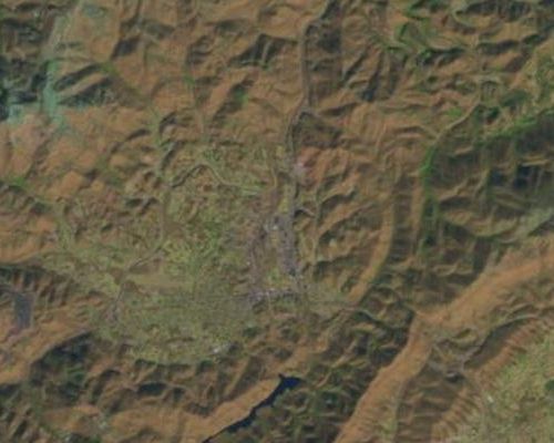
| Description |
Polski: Miasto i krater uderzeniowy Middlesboro w Kentucky. Krawędź krateru jest widoczna na prawo od centrum. English: Middlesboro: impact crater and city in Kentucky. Crater rim is visible right of center. |
| Date | |
| Source | USGS: LandsatLook Viewer |
| Author | USGS/NASA Landsat Program; found and cropped by Szczureq |
Licensing[edit]
| This file is in the public domain in the United States because it was solely created by NASA. NASA copyright policy states that "NASA material is not protected by copyright unless noted". (See Template:PD-USGov, NASA copyright policy page or JPL Image Use Policy.) | ||
 |
Warnings:
|
File history
Click on a date/time to view the file as it appeared at that time.
| Date/Time | Thumbnail | Dimensions | User | Comment | |
|---|---|---|---|---|---|
| current | 15:54, 10 June 2014 | | 500 × 400 (37 KB) | Szczureq (talk | contribs) | User created page with UploadWizard |
You cannot overwrite this file.
File usage on Commons
There are no pages that use this file.
File usage on other wikis
The following other wikis use this file:
- Usage on pl.wikipedia.org