File:Militargrenze, Wojwodowena und Banat.jpg
Originaldatei (900 × 312 Pixel, Dateigröße: 115 KB, MIME-Typ: image/jpeg)
Bildtexte
Kurzbeschreibungen
| Beschreibung |
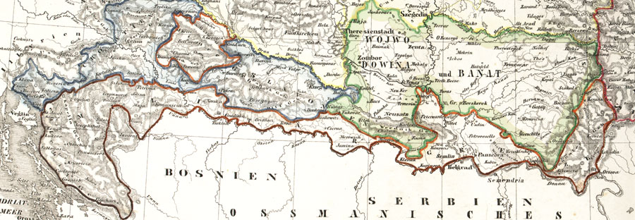
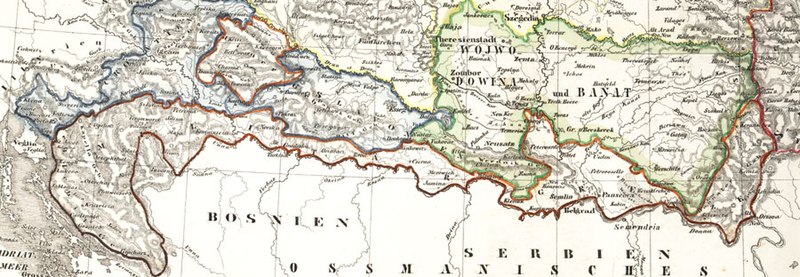
Deutsch: Karte der österreichischen Militärgrenze aus dem 19. Jahrhundert.
English: Historic map of the military frontier of Austria-Hungary, also named Krajina, and of Vojvodina
Français : Carte historique des confins militaires en Autriche-Hongrie aussi appelé Krajina |
||||
| Datum | 2004 | ||||
| Quelle | de:Bild:Militärgrenze.jpg | ||||
| Urheber | Scan plp | ||||
| Genehmigung (Weiternutzung dieser Datei) |
|
||||
| Andere Versionen |
 |
||||
| Bildnotizen | Diese Datei ist annotiert: Betrachte diese auf Commons. |
Dateiversionen
Klicke auf einen Zeitpunkt, um diese Version zu laden.
| Version vom | Vorschaubild | Maße | Benutzer | Kommentar | |
|---|---|---|---|---|---|
| aktuell | 04:57, 26. Sep. 2008 | 900 × 312 (115 KB) | Nikola Smolenski (Diskussion | Beiträge) | {{Information |Description={{de|Karte der österreichischen de:Militärgrenze aus dem 19. Jahrhundert.}} {{en|Historic map of the military frontier of Austria-Hungary, also named w:Krajina, and of w:Vojvodina}} {{fr|Carte historique des con |
Du kannst diese Datei nicht überschreiben.
Dateiverwendung
Die folgenden 6 Seiten verwenden diese Datei:
Globale Dateiverwendung
Die nachfolgenden anderen Wikis verwenden diese Datei:
- Verwendung auf azb.wikipedia.org
- Verwendung auf be-tarask.wikipedia.org
- Verwendung auf bg.wikipedia.org
- Verwendung auf bs.wikipedia.org
- Verwendung auf cs.wikipedia.org
- Verwendung auf da.wikipedia.org
- Verwendung auf de.wikipedia.org
- Verwendung auf en.wikipedia.org
- Verwendung auf eo.wikipedia.org
- Verwendung auf es.wikipedia.org
- Verwendung auf et.wikipedia.org
- Verwendung auf fa.wikipedia.org
- Verwendung auf fr.wikipedia.org
- Verwendung auf gl.wikipedia.org
- Verwendung auf hr.wikipedia.org
- Verwendung auf hu.wikipedia.org
- Verwendung auf id.wikipedia.org
- Verwendung auf it.wikipedia.org
- Verwendung auf ja.wikipedia.org
Weitere globale Verwendungen dieser Datei anschauen.
Metadaten
- Voivodeship of Serbia and Banat of Temeschwar
- Maps of the Habsburg Military Frontier
- Kingdom of Croatia (Habsburg)
- Kingdom of Slavonia
- 19th-century maps of Croatia
- 19th-century maps of Serbia
- Old maps of Vojvodina
- Maps of the Habsburg period in the history of Serbia
- Maps of the history of Vojvodina
- Maps of the history of Banat
- Maps of the history of Bačka
- Maps of the history of Syrmia
- Maps of the history of Croatia (1526–1918)
- Maps of the history of Slavonia
- Old maps of the Austrian Empire