File:Militargrenze, Wojwodowena und Banat.jpg
ナビゲーションに移動
検索に移動
このプレビューのサイズ: 800 × 277 ピクセル。 その他の解像度: 320 × 111 ピクセル | 900 × 312 ピクセル。
元のファイル (900 × 312 ピクセル、ファイルサイズ: 115キロバイト、MIME タイプ: image/jpeg)
キャプション
キャプション
このファイルの内容を1行で記述してください
| 解説 |
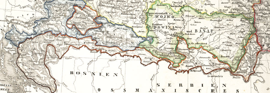
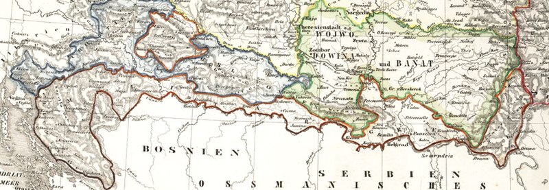
Deutsch: Karte der österreichischen Militärgrenze aus dem 19. Jahrhundert.
English: Historic map of the military frontier of Austria-Hungary, also named Krajina, and of Vojvodina
Français : Carte historique des confins militaires en Autriche-Hongrie aussi appelé Krajina |
||||
| 日付 | 2004 | ||||
| 原典 | de:Bild:Militärgrenze.jpg | ||||
| 作者 | Scan plp | ||||
| 許可 (ファイルの再利用) |
|
||||
| その他のバージョン |
 |
||||
| 注釈 | この画像には注釈がついています: コモンズで注釈を見る |
ファイルの履歴
過去の版のファイルを表示するには、その版の日時をクリックしてください。
| 日付と時刻 | サムネイル | 寸法 | 利用者 | コメント | |
|---|---|---|---|---|---|
| 現在の版 | 2008年9月26日 (金) 04:57 | 900 × 312 (115キロバイト) | Nikola Smolenski (トーク | 投稿記録) | {{Information |Description={{de|Karte der österreichischen de:Militärgrenze aus dem 19. Jahrhundert.}} {{en|Historic map of the military frontier of Austria-Hungary, also named w:Krajina, and of w:Vojvodina}} {{fr|Carte historique des con |
このファイルは上書きできません。
ファイルの使用状況
以下の 6 ページがこのファイルを使用しています:
グローバルなファイル使用状況
以下に挙げる他のウィキがこの画像を使っています:
- azb.wikipedia.org での使用状況
- be-tarask.wikipedia.org での使用状況
- bg.wikipedia.org での使用状況
- bs.wikipedia.org での使用状況
- cs.wikipedia.org での使用状況
- da.wikipedia.org での使用状況
- de.wikipedia.org での使用状況
- en.wikipedia.org での使用状況
- eo.wikipedia.org での使用状況
- es.wikipedia.org での使用状況
- et.wikipedia.org での使用状況
- fa.wikipedia.org での使用状況
- fr.wikipedia.org での使用状況
- gl.wikipedia.org での使用状況
- hr.wikipedia.org での使用状況
- hu.wikipedia.org での使用状況
- id.wikipedia.org での使用状況
- it.wikipedia.org での使用状況
- ja.wikipedia.org での使用状況
このファイルのグローバル使用状況を表示する。
メタデータ
カテゴリ:
- Voivodeship of Serbia and Banat of Temeschwar
- Maps of the Habsburg Military Frontier
- Kingdom of Croatia (Habsburg)
- Kingdom of Slavonia
- 19th-century maps of Croatia
- 19th-century maps of Serbia
- Old maps of Vojvodina
- Maps of the Habsburg period in the history of Serbia
- Maps of the history of Vojvodina
- Maps of the history of Banat
- Maps of the history of Bačka
- Maps of the history of Syrmia
- Maps of the history of Croatia (1526–1918)
- Maps of the history of Slavonia
- Old maps of the Austrian Empire