File:Mission-hills-ks-map.gif
Jump to navigation
Jump to search
No higher resolution available.
Mission-hills-ks-map.gif (575 × 425 pixels, file size: 82 KB, MIME type: image/gif)
Captions
Captions
Add a one-line explanation of what this file represents
Summary
[edit]
| Description | |
| Date | |
| Source | http://factfinder.census.gov/ |
| Author | United States Census Bureau |
| Permission (Reusing this file) |
PD-USGOV-DOC-CENSUS |
Licensing
[edit]
This image or file is a work of a United States Census Bureau employee, taken or made as part of that person's official duties. As a work of the U.S. federal government, the image is in the public domain.
|
 |
Original upload log
[edit]
The original description page was here. All following user names refer to en.wikipedia.
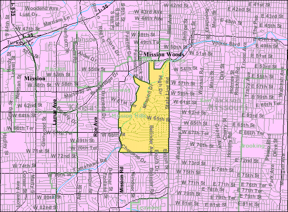
- 2008-03-04 12:22 Americasroof 575×425× (84441 bytes) {{Information |Description=U.S. Census Map |Source=U.S. Census Map |Date=March 2008 |Location=[[Mission Hills, Kansas]] |Author=U.S. Census |Permission=U.S. Census Government |other_versions= }}
File history
Click on a date/time to view the file as it appeared at that time.
| Date/Time | Thumbnail | Dimensions | User | Comment | |
|---|---|---|---|---|---|
| current | 23:29, 9 July 2011 | | 575 × 425 (82 KB) | File Upload Bot (Magnus Manske) (talk | contribs) | {{BotMoveToCommons|en.wikipedia|year={{subst:CURRENTYEAR}}|month={{subst:CURRENTMONTHNAME}}|day={{subst:CURRENTDAY}}}} {{Information |Description={{en|en:U.S. Census 2000 reference map for en:Mission Hills, Kansas}} |Source=Transferred from [ |
You cannot overwrite this file.
File usage on Commons
There are no pages that use this file.
File usage on other wikis
The following other wikis use this file:
- Usage on en.wikipedia.org
- Usage on fa.wikipedia.org
- Usage on sh.wikipedia.org