File:Mito kouku haisuitou 19750113 L.jpg
Jump to navigation
Jump to search

Size of this preview: 497 × 600 pixels. Other resolutions: 199 × 240 pixels | 498 × 601 pixels.
Original file (498 × 601 pixels, file size: 165 KB, MIME type: image/jpeg)
Captions
Captions
Add a one-line explanation of what this file represents
Summary
[edit]
| Description |
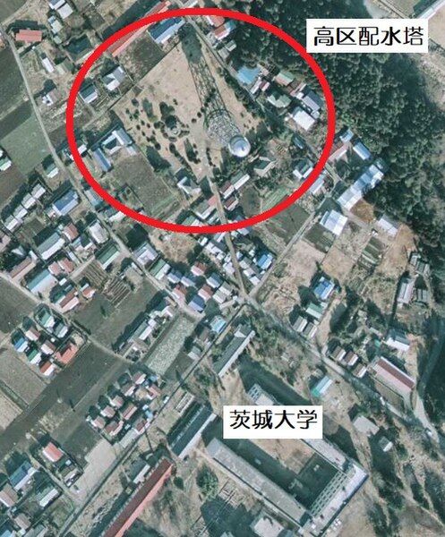
日本語: 水戸市水道高区配水塔付近空中写真(国土地理院 1975/01/13(昭50)撮影) |
| Date | |
| Source | 国土地理院地図・空中閲覧サービス 空中写真 (整理番号:CKT7412 コース:C10 撮影年月日:1975/01/13(昭50))[該当画像へのリンク https://mapps.gsi.go.jp/contentsImageDisplay.do?specificationId=1952840&isDetail=true] |
| Author | 国土地理院 |
Licensing
[edit]

|
This work is licensed under the Government of Japan Standard Terms of Use (Ver.2.0). The Terms of Use are compatible with the Creative Commons Attribution License 4.0 International. For the terms of use of this work, see this license page.
|
This file is licensed under the Creative Commons Attribution 4.0 International license.
Attribution: 国土地理院 (GSI)
- You are free:
- to share – to copy, distribute and transmit the work
- to remix – to adapt the work
- Under the following conditions:
- attribution – You must give appropriate credit, provide a link to the license, and indicate if changes were made. You may do so in any reasonable manner, but not in any way that suggests the licensor endorses you or your use.
File history
Click on a date/time to view the file as it appeared at that time.
| Date/Time | Thumbnail | Dimensions | User | Comment | |
|---|---|---|---|---|---|
| current | 12:30, 29 July 2023 | | 498 × 601 (165 KB) | 七巫こ (talk | contribs) | 投稿者書き込み版 |
| 12:26, 29 July 2023 |  | 498 × 601 (159 KB) | 七巫こ (talk | contribs) | Uploaded a work by 国土地理院 from 国土地理院地図・空中閲覧サービス 空中写真 (整理番号:CKT7412 コース:C10 撮影年月日:1975/01/13(昭50)) with UploadWizard |
You cannot overwrite this file.
File usage on Commons
There are no pages that use this file.
File usage on other wikis
The following other wikis use this file:
- Usage on ja.wikipedia.org