File:Miyamoto Crater.JPG
跳转到导航
跳转到搜索
没有更高的分辨率。
Miyamoto_Crater.JPG (524 × 464像素,文件大小:34 KB,MIME类型:image/jpeg)
说明
说明
添加一行文字以描述该文件所表现的内容
摘要[编辑]
| 描述 |
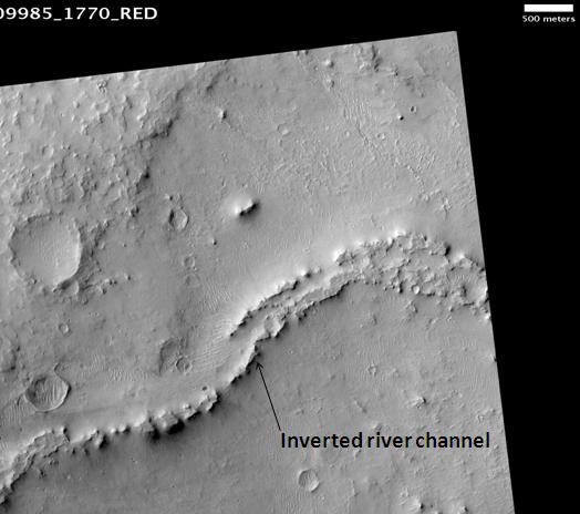
English: Miyamoto Crater, as seen by hirise. The location is 3 degrees south latitude and 352.1 degrees east longitude. Image was taken by the Mars Reconnaissance Orbiter's HiRISE. The HiRISE camera was built by Ball Aerospace and Technology orporation and is operated by the University of Arizona. Image courtesy NASA/JPL/University of Arizona. |
|||||
| 日期 | ||||||
| 来源 | http://hirise.lpl.arizona.edu/PSP_009985_1770. 本檔案是由Magnus Manske使用CommonsHelper,從en.wikipedia轉移到維基共享資源。 | |||||
| 作者 | NASA/JPL/University of Arizona. Jim Secosky (Jimmarsmars) modified NASA image. | |||||
| 授权 (二次使用本文件) |
|

| 火星上的位置 | 在以下服务上查看本图像和附近其他图像: Google地图 |
|---|
原始上传日志[编辑]
原始描述頁面位於這裡。下列使用者名稱均來自en.wikipedia。
- 2009-02-25 17:01 Jimmarsmars 524×464× (34352 bytes) {{Information |Description=Miyamoto Crater, as seen by hirise. The location is 3 degrees south latitude and 352.1 degrees east longitude. |Source=http://hirise.lpl.arizona.edu/PSP_009985_1770 |Date=February 25, 2009 |Author=Jim Secosky modified NASA ima
文件历史
点击某个日期/时间查看对应时刻的文件。
| 日期/时间 | 缩略图 | 大小 | 用户 | 备注 | |
|---|---|---|---|---|---|
| 当前 | 2011年2月20日 (日) 12:33 | | 524 × 464(34 KB) | File Upload Bot (Magnus Manske)(留言 | 贡献) | {{BotMoveToCommons|en.wikipedia|year={{subst:CURRENTYEAR}}|month={{subst:CURRENTMONTHNAME}}|day={{subst:CURRENTDAY}}}} {{Information |Description={{en|Miyamoto Crater, as seen by hirise. The location is 3 degrees south latitude and 352.1 degrees east lo |
您不可以覆盖此文件。
文件用途
没有页面使用本文件。
全域文件用途
以下其他wiki使用此文件:
- el.wikipedia.org上的用途
- en.wikipedia.org上的用途
- fr.wikipedia.org上的用途
- mk.wikipedia.org上的用途
- pl.wikipedia.org上的用途
- pnb.wikipedia.org上的用途
- ru.wikipedia.org上的用途
- ur.wikipedia.org上的用途
- zh.wikipedia.org上的用途