File:Molave 2020-10-27 0550Z.jpg

Original file (1,774 × 1,478 pixels, file size: 1.57 MB, MIME type: image/jpeg)
Captions
Captions
Summary
[edit]
| Description |
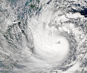
English: Vietnam has been pummeled by three deadly storms this October, causing the worst flooding in decades. Now, another powerful typhoon is headed toward the country.
Typhoon Molave was forecasted to make landfall in southern Vietnam on the morning of October 28, 2020. Meteorologists predicted that the storm would bring 100 to 200 millimeters (4 to 8 inches) of rain near landfall and could potentially trigger landslides in mountainous areas. Officials in Vietnam have ordered evacuations for more than a million residents. The storm may also bring rainfall to Thailand and the island of Hainan, China. On October 27, 2020, the Moderate Resolution Imaging Spectroradiometer (MODIS) on NASA’ Aqua satellite captured this image of Molave as it crossed the South China Sea. Molave passed through the Philippines on October 26 and 27 (locally known as Quinta) displacing thousands of residents, flooding villages, and causing several deaths. The storm has since intensified and is likely to maintain its strength as it crosses warm waters and an area with low wind shear. The storm is expected to make landfall with sustained winds of 135 to 180 kilometers (85 to 115 miles) per hour. Vietnam is already reeling from weeks of intense flooding caused by three tropical storms since October 11. Although October is part of rainy season for the country, the weather has been exacerbated by a La Niña event. La Niña is characterized by usually cold temperatures in the eastern equatorial Pacific Ocean and warmer water in the western Pacific, which leads to wetter-than-normal conditions to Southeast Asia. |
| Date | |
| Source | https://earthobservatory.nasa.gov/images/147456/molave-heads-toward-vietnam |
| Author | NASA Earth Observatory image by Lauren Dauphin, using MODIS data from NASA EOSDIS/LANCE and GIBS/Worldview. Story by Kasha Patel. |
Licensing
[edit]
| This file is in the public domain in the United States because it was solely created by NASA. NASA copyright policy states that "NASA material is not protected by copyright unless noted". (See Template:PD-USGov, NASA copyright policy page or JPL Image Use Policy.) | ||
 |
Warnings:
|
File history
Click on a date/time to view the file as it appeared at that time.
| Date/Time | Thumbnail | Dimensions | User | Comment | |
|---|---|---|---|---|---|
| current | 23:40, 10 May 2023 | | 1,774 × 1,478 (1.57 MB) | Nino Marakot (talk | contribs) | Uploaded a work by NASA Earth Observatory image by Lauren Dauphin, using MODIS data from NASA EOSDIS/LANCE and GIBS/Worldview. Story by Kasha Patel. from https://earthobservatory.nasa.gov/images/147456/molave-heads-toward-vietnam with UploadWizard |
You cannot overwrite this file.
File usage on Commons
There are no pages that use this file.
File usage on other wikis
The following other wikis use this file:
- Usage on vi.wikipedia.org