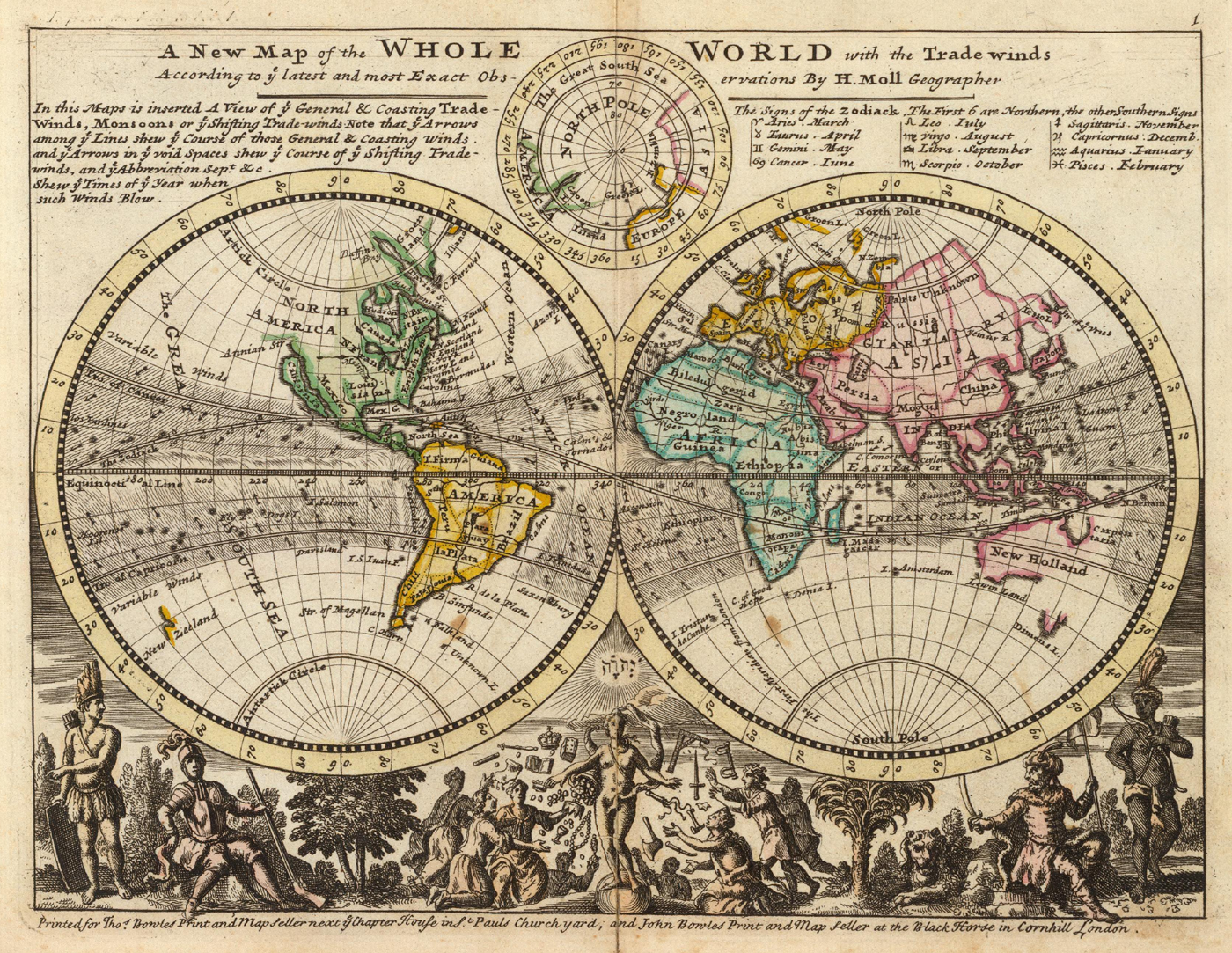
File:Moll - A new map of the whole world with the trade winds.png
Aller à la navigation
Aller à la recherche
Taille de cet aperçu : 775 × 600 pixels. Autres résolutions : 310 × 240 pixels | 621 × 480 pixels | 993 × 768 pixels | 1 280 × 990 pixels | 1 400 × 1 083 pixels.
Fichier d’origine (1 400 × 1 083 pixels, taille du fichier : 3,22 Mio, type MIME : image/png)
Légendes
Légendes
Ajoutez en une ligne la description de ce que représente ce fichier
Description[modifier]
| Description |
English: Title: A New Map of the Whole World with the Trade Winds... |
|||||||||||||||||||||||
| Date | ||||||||||||||||||||||||
| Source | Atlas Minor, 3rd ed. (London) | |||||||||||||||||||||||
| Auteur |
|
|||||||||||||||||||||||
| Autres versions |
|
|||||||||||||||||||||||


_-_region_Indian_Ocean-New_Holland-Dimens_Land.png)
Conditions d’utilisation[modifier]
|
L’auteur est mort en 1732 ; cette œuvre est donc également dans le domaine public dans tous les pays pour lesquels le droit d’auteur a une durée de vie de 100 ans ou moins après la mort de l’auteur. Cette œuvre est dans le domaine public aux États-Unis car elle a été publiée avant le 1er janvier 1929. | |
| Ce fichier a été identifié comme étant exempt de restrictions connues liées au droit d’auteur, y compris tous les droits connexes et voisins. | |
Historique du fichier
Cliquer sur une date et heure pour voir le fichier tel qu'il était à ce moment-là.
| Date et heure | Vignette | Dimensions | Utilisateur | Commentaire | |
|---|---|---|---|---|---|
| actuel | 13 septembre 2005 à 16:06 | | 1 400 × 1 083 (3,22 Mio) | Frank Schulenburg (d | contributions) | Herman Moll: ''A new map of the whole world with the trade winds'', 1736 {{Creator:Herman Moll}} Category:18th century maps |
Vous ne pouvez pas remplacer ce fichier.
Utilisations locales du fichier
Les 5 pages suivantes utilisent ce fichier :
- Herman Moll
- File:A new map of the whole world with the trade winds according to ye latest and most exact observations - Norman B. Leventhal Map Center at the BPL.jpg
- File:A new map of the whole world with the trade winds according to ye latest and most exact observations LOC 2017585657.jpg
- File:A new map of the whole world with the trade winds according to ye latest and most exact observations LOC 2017585657.tif
- File:Moll - A new map of the whole world with the trade winds (cropped) - region Indian Ocean-New Holland-Dimens Land.png
Utilisations du fichier sur d’autres wikis
Les autres wikis suivants utilisent ce fichier :
- Utilisation sur ca.wikipedia.org
- Utilisation sur cs.wikipedia.org
- Utilisation sur de.wikipedia.org
- Utilisation sur de.wikiversity.org
- Utilisation sur en.wikipedia.org
- Utilisation sur eo.wikipedia.org
- Utilisation sur es.wikipedia.org
- Utilisation sur fa.wikipedia.org
- Utilisation sur fr.wikipedia.org
- Utilisation sur he.wikipedia.org
- Utilisation sur lb.wikipedia.org
- Utilisation sur pl.wikipedia.org
- Utilisation sur pt.wikipedia.org
- Utilisation sur simple.wikipedia.org
- Utilisation sur tr.wikipedia.org