File:Mollusc shells on marine beach (Cayo Costa Island, Florida, USA) 5 (24219418732).jpg

Originaldatei (4.000 × 3.000 Pixel, Dateigröße: 3,02 MB, MIME-Typ: image/jpeg)
Bildtexte
Kurzbeschreibungen
Beschreibung
[Bearbeiten]_5_(24219418732).jpg&action=edit§ion=1)
| Beschreibung |
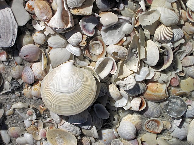
Mollusc shells on a marine beach at the southern tip of Cayo Costa Island, Florida, USA (January 2016). Cayo Costa Island is one of dozens of barrier islands in the West-Central Florida Barrier Chain. This 191-mile long, slightly sinuous stretch of islands is located along the Gulf of Mexico coast of southern Florida. The southern-most island in the chain is Cape Romano Island. The northern-most islands are the Anclote Keys. Cayo Costa Island is located between North Captiva Island and Gasparilla Island, offshore from the towns of Fort Myers and Cape Coral, Florida. Most of Cayo Costa Island is a state park and is only accessible by boat. Cayo Costa is on the western side of Pine Island Sound, a large lagoon just south of Charlotte Harbor. Two large tidal inlets border Cayo Costa Island - Captiva Pass to the south and Boca Grande Pass to the north. Cayo Costa is a classic example of a drumstick barrier island - it is wide on its northern end and tapers to a point or hook on its southern end. This shape is the result of long-shore currents along the coastline. Other islands in the barrier chain also have this morphology. Cayo Costa Island and nearby North Captiva Island, Captiva Island, and Sanibel Island are Holocene barriers that rim the western and southern sides of a Late Miocene depression that is now Pine Island Sound. Middle Miocene limestone bedrock was subject to significant dissolution and karst/cave development. The Pine Island Sound area was a large karst depression in the Late Miocene. It is now filled with sediments - most of modern Pine Island Sound is significantly shallow. The beaches of Cayo Costa Island are famous for having an abundance of shells - they form moderately thick piles along much of the island's shoreline. The relative abundance and quality of shells varies from site to site and with weather & seasonal conditions. The shells shown above are 99% bivalves, but gastropods, echinoids, and other organisms are also present. The large, articulated clam shell is an elegant dosinia, Dosinia elegans. West-Central Florida Barrier Chain geologic info. synthesized from: Evans et al. (1985) - Bedrock controls on barrier island development: west-central Florida coast. Marine Geology 63: 263-283. Davis (1989) - Morphodynamics of the West-Central Florida barrier system: the delicate balance between wave- and tide-domination. Proceedings, Koninklijk Nederlands Geologisch Mijnbouwkundig Genootschap Symposium, 'Coastal Lowlands, Geology and Geotechnology', 1987: 225-235. Evans et al. (1989) - Quaternary stratigraphy of the Charlotte Harbor estuarine-lagoon system, southwest Florida: implications of the carbonate-siliciclastic transition. Marine Geology 88: 319-348. |
| Datum | |
| Quelle | Mollusc shells on marine beach (Cayo Costa Island, Florida, USA) 5 |
| Urheber | James St. John |
Lizenz
[Bearbeiten]_5_(24219418732).jpg&action=edit§ion=2)
- Dieses Werk darf von dir
- verbreitet werden – vervielfältigt, verbreitet und öffentlich zugänglich gemacht werden
- neu zusammengestellt werden – abgewandelt und bearbeitet werden
- Zu den folgenden Bedingungen:
- Namensnennung – Du musst angemessene Urheber- und Rechteangaben machen, einen Link zur Lizenz beifügen und angeben, ob Änderungen vorgenommen wurden. Diese Angaben dürfen in jeder angemessenen Art und Weise gemacht werden, allerdings nicht so, dass der Eindruck entsteht, der Lizenzgeber unterstütze gerade dich oder deine Nutzung besonders.
| Diese Bilddatei wurde ursprünglich auf Flickr durch James St. John in https://flickr.com/photos/47445767@N05/24219418732 hochgeladen. Sie wurde am 14. August 2016 durch den FlickreviewR-Bot geprüft und die Lizenzierung der Datei unter den Bedingungen von cc-by-2.0 wurde bestätigt. |
Dateiversionen
Klicke auf einen Zeitpunkt, um diese Version zu laden.
| Version vom | Vorschaubild | Maße | Benutzer | Kommentar | |
|---|---|---|---|---|---|
| aktuell | 17:27, 14. Aug. 2016 | | 4.000 × 3.000 (3,02 MB) | Ser Amantio di Nicolao (Diskussion | Beiträge) | Transferred from Flickr via Flickr2Commons |
Du kannst diese Datei nicht überschreiben.
Dateiverwendung
Keine Seiten verwenden diese Datei.
Globale Dateiverwendung
Die nachfolgenden anderen Wikis verwenden diese Datei:
- Verwendung auf de.wikipedia.org
- Verwendung auf fr.wikipedia.org
_5_(24219418732).jpg&oldid=676598202)