File:Monitin Hakaffa Map 1.jpg
Jump to navigation
Jump to search
Size of this preview: 495 × 600 pixels. Other resolutions: 198 × 240 pixels | 572 × 693 pixels.
Original file (572 × 693 pixels, file size: 133 KB, MIME type: image/jpeg)
Captions
Captions
Add a one-line explanation of what this file represents
Summary
[edit]
| Description |
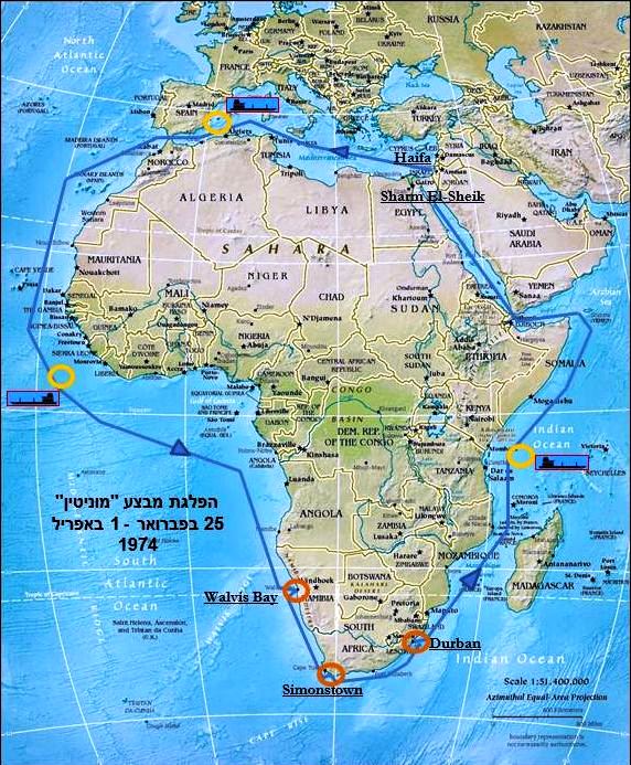
עברית: , מסלול הפלגת הספינות מחיפה לשארם א-שייח' פברואר -מרץ 1974. |
| Date | |
| Source |
Own work based on AfricaCIA-HiRes.jpg This file was derived from: AfricaCIA-HiRes.jpg |
| Author |
|
| Permission (Reusing this file) |
Licensing
[edit]
I, the copyright holder of this work, hereby publish it under the following license:
This file is licensed under the Creative Commons Attribution-Share Alike 4.0 International license.
- You are free:
- to share – to copy, distribute and transmit the work
- to remix – to adapt the work
- Under the following conditions:
- attribution – You must give appropriate credit, provide a link to the license, and indicate if changes were made. You may do so in any reasonable manner, but not in any way that suggests the licensor endorses you or your use.
- share alike – If you remix, transform, or build upon the material, you must distribute your contributions under the same or compatible license as the original.
- The oroginal map
This image is in the public domain because it contains materials that originally came from the United States Central Intelligence Agency's World Factbook.
|
 |
File history
Click on a date/time to view the file as it appeared at that time.
| Date/Time | Thumbnail | Dimensions | User | Comment | |
|---|---|---|---|---|---|
| current | 07:21, 10 May 2016 | | 572 × 693 (133 KB) | קודקוד צהוב (talk | contribs) | הוספת נקודות תדלוק בים והדגשת נמלים שבהם נערכו ביקורים |
| 18:15, 4 April 2015 |  | 590 × 720 (117 KB) | Kufxh (talk | contribs) | User created page with UploadWizard |
You cannot overwrite this file.
File usage on Commons
The following 2 pages use this file:
File usage on other wikis
The following other wikis use this file:
- Usage on he.wikipedia.org