File:Mont Mounier 001def.jpg
Jump to navigation
Jump to search

Size of this preview: 398 × 599 pixels. Other resolutions: 159 × 240 pixels | 536 × 807 pixels.
Original file (536 × 807 pixels, file size: 116 KB, MIME type: image/jpeg)
Captions
Captions
Add a one-line explanation of what this file represents
Summary
[edit]
| Description |
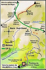
Français : Accès au Mont-Mounier et voies de communication pédestres revus et complétés par André Payan-Passeron à partir du fond de carte page 30 de la plaquette "RANDO Haut Pays" éditée en 2000 par le Conseil général des Alpes Maritimes et préfacée par Charles GINESY (1922-2012) alors sénateur, président du conseil général des Alpes Maritimes, maire de Péone-Valberg et président du Parc national du Mercantour. |
| Date | |
| Source | Own work |
| Author | André Payan-Passeron |
Licensing
[edit]
I, the copyright holder of this work, hereby publish it under the following license:
This file is licensed under the Creative Commons Attribution-Share Alike 3.0 Unported license.
- You are free:
- to share – to copy, distribute and transmit the work
- to remix – to adapt the work
- Under the following conditions:
- attribution – You must give appropriate credit, provide a link to the license, and indicate if changes were made. You may do so in any reasonable manner, but not in any way that suggests the licensor endorses you or your use.
- share alike – If you remix, transform, or build upon the material, you must distribute your contributions under the same or compatible license as the original.
File history
Click on a date/time to view the file as it appeared at that time.
| Date/Time | Thumbnail | Dimensions | User | Comment | |
|---|---|---|---|---|---|
| current | 07:14, 5 January 2013 | | 536 × 807 (116 KB) | André Payan-Passeron (talk | contribs) | User created page with UploadWizard |
You cannot overwrite this file.
File usage on Commons
There are no pages that use this file.