File:Montauk Point Light in storm.jpg
跳转到导航
跳转到搜索

本预览的尺寸:401 × 600像素。 其他分辨率:160 × 240像素 | 321 × 480像素 | 1,003 × 1,500像素。
原始文件 (1,003 × 1,500像素,文件大小:557 KB,MIME类型:image/jpeg)
说明
说明
添加一行文字以描述该文件所表现的内容
| 描述 |
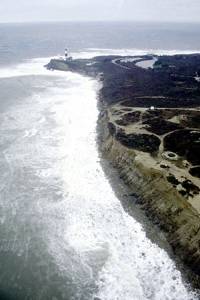
English: Montauk Point on the easternmost extremity of Long Island, New York, USA. View is from the northern side of the point looking southeast. Block Island Sound is to the left and the Atlantic Ocean is straight ahead in this photograph. |
|||
| 日期 | 1999-03-16(Caution: Dates provided by U.S. Army Corps of Engineers web pages are not reliable and are often wrong.) | |||
| 来源 |
U.S. Army Corps of Engineers Digital Visual Library Image page Image description page Digital Visual Library home page |
|||
| 作者 | U.S. Army Corps of Engineers, photographer not specified or unknown | |||
| 授权 (二次使用本文件) |
|
|||
| 图中地点 | Montauk Point, Suffolk County, New York, USA |
| 相机位置 | | 在以下服务上查看本图像和附近其他图像: OpenStreetMap |
|---|
文件历史
点击某个日期/时间查看对应时刻的文件。
| 日期/时间 | 缩略图 | 大小 | 用户 | 备注 | |
|---|---|---|---|---|---|
| 当前 | 2007年4月9日 (一) 04:38 | | 1,003 × 1,500(557 KB) | DanMS(留言 | 贡献) | {{Information | Description = {{en|Montauk Point on the easternmost extremity of Long Island, New York, USA. View is from the northern side of the point looking southeast. Block Island Sound is to the left and the Atlantic Ocean is straight ahead in th |
您不可以覆盖此文件。
文件用途
没有页面使用本文件。
全域文件用途
以下其他wiki使用此文件:
- ar.wikipedia.org上的用途
- bg.wikipedia.org上的用途
- de.wikipedia.org上的用途
- en.wikipedia.org上的用途
- eo.wikipedia.org上的用途
- fr.wikipedia.org上的用途
- zh.wikipedia.org上的用途