File:Montenegro-un-cs.png

Original file (537 × 613 pixels, file size: 162 KB, MIME type: image/png)
Captions
Captions
| Description |
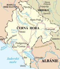
Mapa Černé Hory Map of Montenegro |
| Source | Own work |
| Author | Zirland |
| Other versions | Image:Montenegro-un.png |
This file is in the public domain because permission given by UN as set out below
|
| This image is a map derived from a United Nations map.
Unless stated otherwise, UN maps are to be considered in the public domain. This applies worldwide. UN maps are, in principle, open source material and you can use them in your work or for making your own map. UN requests however that you delete the UN name, logo and reference number upon any modification to the map. Content of your map will be your responsibility. You can state in your publication, if you wish, something like: based on UN map … (map name, map number, revision number and date). See: Geospatial Information Section. And: Geospatial, location data for a better world. |
 |
File history
Click on a date/time to view the file as it appeared at that time.
| Date/Time | Thumbnail | Dimensions | User | Comment | |
|---|---|---|---|---|---|
| current | 16:24, 6 May 2007 | | 537 × 613 (162 KB) | Zirland (talk | contribs) | {{Information |Description=Mapa Černé Hory<br>Map of Montenegro |Source=self-made |Date= |Author= User:Zirland |other_versions=Image:Montenegro-un.png }} {{PD-OSNMap}} |
You cannot overwrite this file.
File usage on Commons
There are no pages that use this file.
File usage on other wikis
The following other wikis use this file:
- Usage on cs.wikipedia.org