File:Moon Farside LRO.jpg

原始文件 (18,000 × 18,000像素,文件大小:85.34 MB,MIME类型:image/jpeg)
说明
说明
| 警告 | 部分浏览器在浏览此图片的完整大小时可能会遇到困难:该图片中有数量巨大的像素点,可能无法完全载入或者导致您的浏览器停止响应。 |
|---|
Lower-resolution versions: 6000px, 3000px, and 1000px
摘要[编辑]
| 描述 |
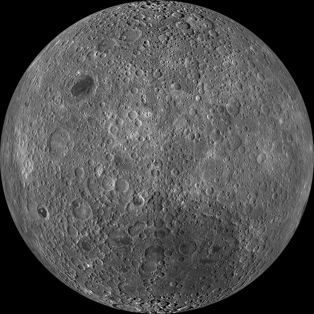
English: Far side of the moon, by NASA's Lunar Reconnaissance Orbiter. Orthographic projection centred at 180° longitude, 0° latitude.
Because the moon is tidally locked (meaning the same side always faces Earth), it was not until 1959 that the farside was first imaged by the Soviet Luna 3 spacecraft (hence the Russian names for prominent farside features, such as Mare Moscoviense). And what a surprise – unlike the widespread maria on the nearside, basaltic volcanism was restricted to a relatively few, smaller regions on the farside, and the battered highlands crust dominated. A different world from what we saw from Earth. Of course, the cause of the farside/nearside asymmetry is an interesting scientific question. Past studies have shown that the crust on the farside is thicker, likely making it more difficult for magmas to erupt on the surface, limiting the amount of farside mare basalts. Why is the farside crust thicker? That is still up for debate, and in fact several presentations at this week's Lunar and Planetary Science Conference attempt to answer this question. The Clementine mission obtained beautiful mosaics with the sun high in the sky (low phase angles), but did not have the opportunity to observe the farside at sun angles favorable for seeing surface topography. This WAC mosaic provides the most complete look at the morphology of the farside to date and will provide a valuable resource for the scientific community. And it's simply a spectacular sight! The Lunar Reconnaissance Orbiter Camera (LROC) Wide Angle Camera (WAC) is a push-frame camera that captures seven color bands (321, 360, 415, 566, 604, 643, and 689 nm) with a 57 km swath (105 km swath in monochrome mode) from a 50 km orbit. One of the primary objectives of LROC is to provide a global 100 m/px monochrome (643 nm) base map with incidence angles between 55° and 70° at the equator, lighting that is favorable for morphological interpretations. Each month, the WAC provides nearly complete coverage of the Moon under unique lighting. As an added bonus, the orbit-to-orbit image overlap provides stereo coverage. Reducing all these stereo images into a global topographic map is a big job, which is being led by LROC Team Members from the German Aerospace Center (Deutsches Zentrum für Luft- und Raumfahrt; DLR). Several preliminary WAC topographic products have appeared in LROC featured images over the past year (Orientale basin, Sinus Iridum). The WAC topographic dataset will be completed and released later this year. The global mosaic released today is comprised of over 15,000 WAC images acquired between November 2009 and February 2011. The non-polar images were map-projected onto the GLD100 shape model (WAC derived 100 m/px DTM), while polar images were map-projected on the LOLA shape model. In addition, the LOLA-derived crossover-corrected ephemeris and an improved camera pointing provide accurate positioning (better than 100 m) of each WAC image. |
| 日期 | 在2009年11月到2011年2月之间 |
| 来源 | http://wms.lroc.asu.edu/lroc_browse/view/WAC_GL180 (see also http://photojournal.jpl.nasa.gov/catalog/PIA14021) |
| 作者 | NASA/GSFC/Arizona State University |
| 其他版本 | Lower-resolution versions: 6000px, 3000px, and 1000px |
| 此标签不表示文件的著作权状态。任何文件在附有此标签的同時还需要一个有效的著作权标签。请参阅许可协议说明页面以了解更多信息。 其他语言:
|
许可协议[编辑]
| 本文件完全由NASA创作,在美国属于公有领域。根据NASA的版权方针,NASA的材料除非另有声明否则不受版权保护。(参见Template:PD-USGov/zh、NASA版权方针页面或JPL图片使用方针。) | ||
 |
警告:
|
| 注解 | 该图片含有注解:在维基媒体共享资源上查看注解 |
文件历史
点击某个日期/时间查看对应时刻的文件。
| 日期/时间 | 缩略图 | 大小 | 用户 | 备注 | |
|---|---|---|---|---|---|
| 当前 | 2014年3月19日 (三) 23:47 | | 18,000 × 18,000(85.34 MB) | Huntster(留言 | 贡献) | High resolution mosaic. |
| 2011年4月9日 (六) 04:12 |  | 1,600 × 1,600(1.44 MB) | Bubba73(留言 | 贡献) | {{Information |Description ={{en|1=Far side of the Moon, by NASA's Lunar Recon. Orbiter}} |Source =http://apod.nasa.gov/apod/image/1104/farside_lro1600.jpg |Author =NASA - LRO |Date =2011? |Permission = |other_versions = } |
您不可以覆盖此文件。
文件用途
以下页面使用本文件:
全域文件用途
以下其他wiki使用此文件:
- af.wikipedia.org上的用途
- az.wikipedia.org上的用途
- be.wikipedia.org上的用途
- bjn.wikipedia.org上的用途
- bn.wikipedia.org上的用途
- bs.wikipedia.org上的用途
- ca.wikipedia.org上的用途
- cs.wikipedia.org上的用途
- de.wikipedia.org上的用途
- en.wikipedia.org上的用途
- en.wikibooks.org上的用途
- en.wikiversity.org上的用途
- Solar System, technical/Moon
- User:Marshallsumter/Radiation astronomy2/Visuals
- Draft:Original research/Planets
- User:Marshallsumter/Radiation astronomy2/Visuals/Quiz
- User:Marshallsumter/Rocks/Rocky objects/Astronomy
- User:Marshallsumter/Radiation astronomy/Courses/Principles/Hourly 2
- User:Marshallsumter/Radiation astronomy/Courses/Principles/Midterm quiz
- User:Marshallsumter/Radiation astronomy/Courses/Principles/Final quiz
- Titan/Quiz
- User:Marshallsumter/Rocks/Rocky objects
- Draft:Enceladus/Quiz
- Moon/Quiz
- Stars/Sun/Heliology/Quiz
- Earth/Quiz
- Stars/Reds/Quiz
- Draft:Dione/Quiz
- User:Marshallsumter/Radiation astronomy2/Scattered disks/Quiz
- User:Marshallsumter/Radiation astronomy1/Kuiper belts/Quiz
- Liquids/Liquid objects/Moon
- User:Marshallsumter/Radiation astronomy/Craters
- es.wikipedia.org上的用途
- et.wikipedia.org上的用途
查看本文件的更多全域用途。