File:Mora 2017-05-30 0720Z.jpg
跳至導覽
跳至搜尋

預覽大小:459 × 599 像素。 其他解析度:184 × 240 像素 | 368 × 480 像素 | 588 × 768 像素 | 784 × 1,024 像素 | 1,569 × 2,048 像素 | 7,200 × 9,400 像素。
原始檔案 (7,200 × 9,400 像素,檔案大小:6.59 MB,MIME 類型:image/jpeg)
說明
說明
添加單行說明來描述出檔案所代表的內容
摘要
[編輯]
| 描述 |
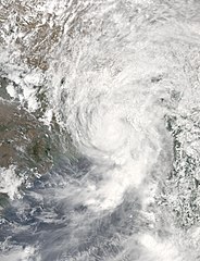
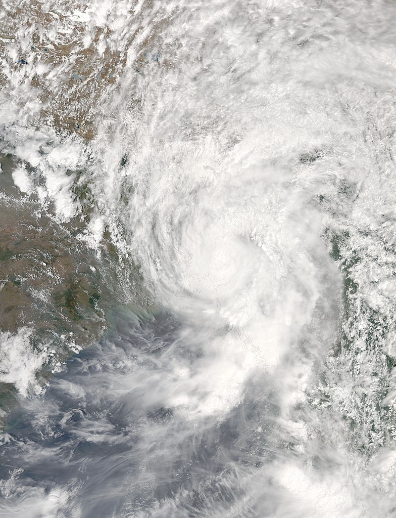
English: Tropical Cyclone Mora (02B) over Bangladesh, India, and Myanmar |
| 日期 | |
| 來源 | https://lance-modis.eosdis.nasa.gov/cgi-bin/imagery/single.cgi?image=Mora.A2017150.0720.250m.jpg |
| 作者 | National Aeronautics and Space Administration, LANCE/EOSDIS Rapid Response, captured on Aqua satellite |
| Metadata | https://lance-modis.eosdis.nasa.gov/cgi-bin/imagery/single.cgi?metadata=Mora.A2017150.0720.txt |
| Satellite | Aqua |
| 拍攝地點 | | 位於此地的本圖片與其他圖片: OpenStreetMap |
|---|
授權條款
[編輯]
| 本作品由NASA創作,屬於公有領域。根據NASA的版權政策:“NASA的創作除非另有聲明否則不受版權保護。”(參見:Template:PD-USGov/zh,NASA版權政策或JPL圖像使用政策) | ||
 |
警告:
|
檔案歷史
點選日期/時間以檢視該時間的檔案版本。
| 日期/時間 | 縮圖 | 尺寸 | 用戶 | 備註 | |
|---|---|---|---|---|---|
| 目前 | 2018年2月11日 (日) 03:03 | | 7,200 × 9,400(6.59 MB) | A1Cafel(對話 | 貢獻) | gallery |
| 2017年8月6日 (日) 01:47 |  | 6,266 × 8,030(6.73 MB) | ChocolateTrain(對話 | 貢獻) | Removed thin black border | |
| 2017年8月6日 (日) 01:44 |  | 6,308 × 8,134(6.78 MB) | ChocolateTrain(對話 | 貢獻) | Enhanced | |
| 2017年5月30日 (二) 10:25 |  | 7,233 × 9,185(4.69 MB) | Typhoon2013(對話 | 貢獻) | User created page with UploadWizard |
無法覆蓋此檔案。
檔案用途
下列3個頁面有用到此檔案:
全域檔案使用狀況
以下其他 wiki 使用了這個檔案:
- el.wikipedia.org 的使用狀況
- en.wikipedia.org 的使用狀況
- es.wikipedia.org 的使用狀況
- ko.wikipedia.org 的使用狀況
- th.wikipedia.org 的使用狀況
- zh.wikipedia.org 的使用狀況