File:Mount Old Baldy Trail View 1.jpg
Jump to navigation
Jump to search

Size of this preview: 800 × 218 pixels. Other resolutions: 320 × 87 pixels | 640 × 174 pixels | 1,024 × 279 pixels | 1,280 × 349 pixels | 6,062 × 1,651 pixels.
Original file (6,062 × 1,651 pixels, file size: 6.93 MB, MIME type: image/jpeg)
Captions
Captions
Add a one-line explanation of what this file represents
Summary
[edit]
| Description |
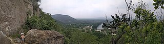
English: Panoramic outlook from the north side of Mount Old Baldy in Garner State Park, Texas, overlooking the Frio River. |
| Date | |
| Source | Own work |
| Author | Doughbo |
| Camera location | | View this and other nearby images on: OpenStreetMap |
|---|
Licensing
[edit]
I, the copyright holder of this work, hereby publish it under the following license:
| This file is made available under the Creative Commons CC0 1.0 Universal Public Domain Dedication. | |
| The person who associated a work with this deed has dedicated the work to the public domain by waiving all of their rights to the work worldwide under copyright law, including all related and neighboring rights, to the extent allowed by law. You can copy, modify, distribute and perform the work, even for commercial purposes, all without asking permission.
|
File history
Click on a date/time to view the file as it appeared at that time.
| Date/Time | Thumbnail | Dimensions | User | Comment | |
|---|---|---|---|---|---|
| current | 00:33, 15 May 2023 | 6,062 × 1,651 (6.93 MB) | Doughbo (talk | contribs) | Uploaded own work with UploadWizard |
You cannot overwrite this file.
File usage on Commons
There are no pages that use this file.
File usage on other wikis
The following other wikis use this file:
- Usage on en.wikipedia.org