File:Muifa 2004-11-17 0455Z.jpg
Jump to navigation
Jump to search

Size of this preview: 466 × 599 pixels. Other resolutions: 187 × 240 pixels | 373 × 480 pixels | 597 × 768 pixels | 796 × 1,024 pixels | 1,593 × 2,048 pixels | 5,600 × 7,200 pixels.
Original file (5,600 × 7,200 pixels, file size: 5.69 MB, MIME type: image/jpeg)
Captions
Captions
Add a one-line explanation of what this file represents
Summary
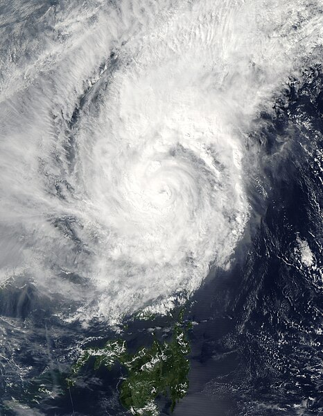
[edit]| Description | Typhoon Muifa spins off the eastern shore of Luzon in this Moderate Resolution Imaging Spectroradiometer (MODIS) image, acquired on November 17, 2004 by NASA’s Aqua satellite. The storm has already drenched the Philippine island of Catanduanes, causing floods and landslides, and is expected to turn west and cross over Luzon before the end of the week. Muifa reached typhoon status at about the time this image was taken at 4:55 UTC. By 12:00 UTC, the storm’s winds reached 139 kilometers per hour (86 mph) with gusts up to 167 kph (103 mph). | |||||
| Date | ||||||
| Source | http://visibleearth.nasa.gov/view_rec.php?id=6721 | |||||
| Author | Jacques Descloitres, MODIS Rapid Response Team, NASA/GSFC | |||||
| Permission (Reusing this file) |
|

File history
Click on a date/time to view the file as it appeared at that time.
| Date/Time | Thumbnail | Dimensions | User | Comment | |
|---|---|---|---|---|---|
| current | 02:35, 6 September 2006 | | 5,600 × 7,200 (5.69 MB) | Good kitty (talk | contribs) | == Summary == {{Information |Description=Typhoon Muifa spins off the eastern shore of Luzon in this Moderate Resolution Imaging Spectroradiometer (MODIS) image, acquired on November 17, 2004 by NASA’s Aqua satellite. The storm has already drenched the P |
You cannot overwrite this file.
File usage on Commons
The following page uses this file:
- File:Typhoon Muifa 2004.jpg (file redirect)
File usage on other wikis
The following other wikis use this file:
- Usage on ja.wikipedia.org
- Usage on th.wikipedia.org
- Usage on vi.wikipedia.org
- Usage on zh.wikipedia.org