File:Muifa 2004-11-17 0455Z.jpg
跳转到导航
跳转到搜索

本预览的尺寸:466 × 599像素。 其他分辨率:187 × 240像素 | 373 × 480像素 | 597 × 768像素 | 796 × 1,024像素 | 1,593 × 2,048像素 | 5,600 × 7,200像素。
原始文件 (5,600 × 7,200像素,文件大小:5.69 MB,MIME类型:image/jpeg)
说明
说明
添加一行文字以描述该文件所表现的内容
摘要
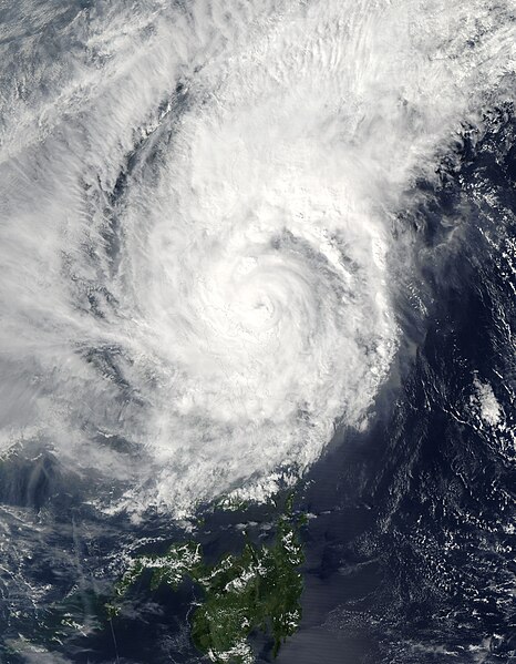
[编辑]| 描述 | Typhoon Muifa spins off the eastern shore of Luzon in this Moderate Resolution Imaging Spectroradiometer (MODIS) image, acquired on November 17, 2004 by NASA’s Aqua satellite. The storm has already drenched the Philippine island of Catanduanes, causing floods and landslides, and is expected to turn west and cross over Luzon before the end of the week. Muifa reached typhoon status at about the time this image was taken at 4:55 UTC. By 12:00 UTC, the storm’s winds reached 139 kilometers per hour (86 mph) with gusts up to 167 kph (103 mph). | |||||
| 日期 | ||||||
| 来源 | http://visibleearth.nasa.gov/view_rec.php?id=6721 | |||||
| 作者 | Jacques Descloitres, MODIS Rapid Response Team, NASA/GSFC | |||||
| 授权 (二次使用本文件) |
|

文件历史
点击某个日期/时间查看对应时刻的文件。
| 日期/时间 | 缩略图 | 大小 | 用户 | 备注 | |
|---|---|---|---|---|---|
| 当前 | 2006年9月6日 (三) 02:35 | | 5,600 × 7,200(5.69 MB) | Good kitty(留言 | 贡献) | == Summary == {{Information |Description=Typhoon Muifa spins off the eastern shore of Luzon in this Moderate Resolution Imaging Spectroradiometer (MODIS) image, acquired on November 17, 2004 by NASA’s Aqua satellite. The storm has already drenched the P |
您不可以覆盖此文件。
文件用途
以下页面使用本文件:
- File:Typhoon Muifa 2004.jpg(文件重定向)
全域文件用途
以下其他wiki使用此文件:
- ja.wikipedia.org上的用途
- th.wikipedia.org上的用途
- vi.wikipedia.org上的用途
- zh.wikipedia.org上的用途