File:Mule Creek Wild and Scenic River Map.jpg
Original file (2,736 × 2,196 pixels, file size: 1,023 KB, MIME type: image/jpeg)
Captions
Captions
Summary[edit]
| Description |
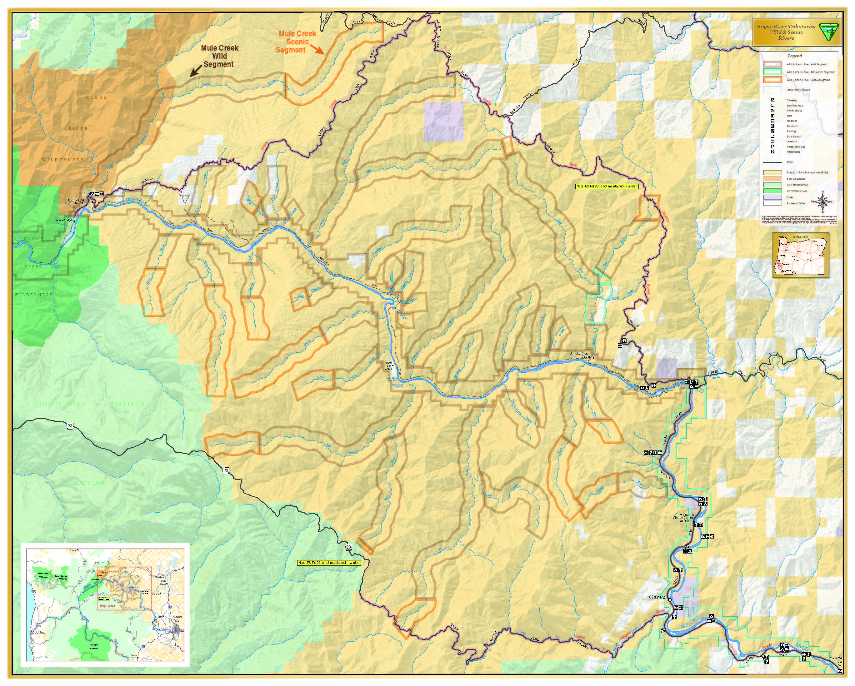
English: On March 12, 2019, President Trump signed the John D. Dingell Jr. Conservation, Management, and Recreation Act (Public Law 116-9 also known as the Dingell Act), a comprehensive public land management bill with over 170 separate sections that affect almost every state in the nation.
Among the spectacular new additions to the National Landscape Conservation System in Oregon/Washington include: • the designation of approximately 200 miles of wild and scenic rivers in the Coos Bay, Medford, and Northwest Oregon Districts. These 48 wild, scenic, and recreational segments are spread across nine newly designated wild and scenic rivers and two pre-existing designations. • the designation of the Devil’s Staircase Wilderness in the Coos Bay District; and • an adjustment of the Deschutes Canyon-Steelhead Falls Wilderness Study Area boundary in the Prineville District in central Oregon. These 48 river segments add to the 25 wild and scenic rivers, comprising over 800 miles, managed BLM in Oregon. These rivers are designated for preservation of their free-flowing condition, water quality, and outstandingly remarkable scenic, recreational, geologic, cultural, or other values and managed in accordance with the Wild and Scenic Rivers Act of 1968. Before visiting these rivers, be sure to check with the local BLM office to learn about the river including river conditions, potential hazards (e.g. underwater terrain) and allowed water activities. Know your limits and pick an appropriate activity for your group's size and ability. Check that everyone has a U.S. Coast Guard approved life jacket and that each person's life jacket fits properly. Develop a Plan B in case things change and you can't do your planned activity. Complete and share your Trip Plan with someone who is not going on the trip. Develop a plan of action so you know what to do if there is an emergency (e.g. you go overboard, your boat flips, hazardous river conditions). Always wear your life jacket! Stick to your intended route. Keep an eye on environmental changes (weather, wildlife, water conditions etc.) and your group to assess if you should continue your trip or turn back. More information on these outstanding National Conservation Lands in Oregon/Washington is available online: www.blm.gov/programs/national-conservation-lands/oregon-w... |
| Date | |
| Source | https://www.flickr.com/photos/50169152@N06/49381890027/ |
| Author | BLM Oregon & Washington |
Licensing[edit]
- You are free:
- to share – to copy, distribute and transmit the work
- to remix – to adapt the work
- Under the following conditions:
- attribution – You must give appropriate credit, provide a link to the license, and indicate if changes were made. You may do so in any reasonable manner, but not in any way that suggests the licensor endorses you or your use.
| This image was originally posted to Flickr by BLM Oregon & Washington at https://flickr.com/photos/50169152@N06/49381890027 (archive). It was reviewed on 17 February 2020 by FlickreviewR 2 and was confirmed to be licensed under the terms of the cc-by-2.0. |
File history
Click on a date/time to view the file as it appeared at that time.
| Date/Time | Thumbnail | Dimensions | User | Comment | |
|---|---|---|---|---|---|
| current | 20:11, 17 February 2020 | | 2,736 × 2,196 (1,023 KB) | Ser Amantio di Nicolao (talk | contribs) | User created page with UploadWizard |
You cannot overwrite this file.
File usage on Commons
There are no pages that use this file.