File:Myanmar location map.svg
跳至導覽
跳至搜尋

此 SVG 檔案的 PNG 預覽的大小:285 × 599 像素。 其他解析度:114 × 240 像素 | 228 × 480 像素 | 365 × 768 像素 | 487 × 1,024 像素 | 975 × 2,048 像素 | 1,200 × 2,520 像素。
原始檔案 (SVG 檔案,表面大小:1,200 × 2,520 像素,檔案大小:633 KB)
說明
說明
添加單行說明來描述出檔案所代表的內容
摘要[編輯]
| 描述 |
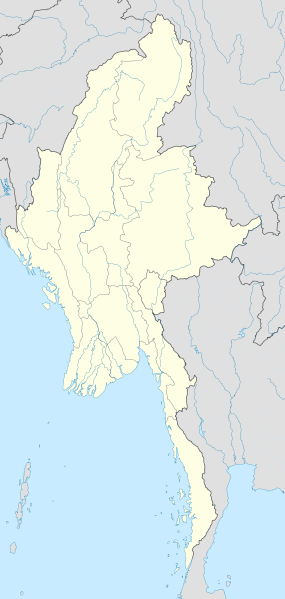
English: Location map of Myanmar. Equirectangular projection. Strechted by 105.0%. Geographic limits of the map: * N: 29.0° N * S: 9.0° N * W: 92.0° E * E: 102.0° E Made with Natural Earth. Free vector and raster map data @ naturalearthdata.com. |
| 日期 | |
| 來源 | 自己的作品 |
| 作者 | Uwe Dedering |
授權條款[編輯]
我,本作品的著作權持有者,決定用以下授權條款發佈本作品:
此檔案採用共享創意 姓名標示-相同方式分享 3.0 未在地化版本授權條款。
- 您可以自由:
- 分享 – 複製、發佈和傳播本作品
- 重新修改 – 創作演繹作品
- 惟需遵照下列條件:
- 姓名標示 – 您必須指名出正確的製作者,和提供授權條款的連結,以及表示是否有對內容上做出變更。您可以用任何合理的方式來行動,但不得以任何方式表明授權條款是對您許可或是由您所使用。
- 相同方式分享 – 如果您利用本素材進行再混合、轉換或創作,您必須基於如同原先的相同或兼容的條款,來分布您的貢獻成品。

|
已授權您依據自由軟體基金會發行的無固定段落、封面文字和封底文字GNU自由文件授權條款1.2版或任意後續版本,對本檔進行複製、傳播和/或修改。該協議的副本列在GNU自由文件授權條款中。 |
您可以選擇您需要的授權條款。
| 註解 | 該圖片含有註解:在維基媒體共享資源上查看註解 |
檔案歷史
點選日期/時間以檢視該時間的檔案版本。
| 日期/時間 | 縮圖 | 尺寸 | 用戶 | 備註 | |
|---|---|---|---|---|---|
| 目前 | 2011年9月29日 (四) 16:08 | | 1,200 × 2,520(633 KB) | NordNordWest(對話 | 貢獻) | corr, see disk |
| 2010年2月18日 (四) 17:45 |  | 1,200 × 2,520(968 KB) | Uwe Dedering(對話 | 貢獻) | no disputed countries | |
| 2010年2月18日 (四) 13:03 |  | 1,200 × 2,520(974 KB) | Uwe Dedering(對話 | 貢獻) | {{Information |Description={{en|1=Location map of Myanmar. Equirectangular projection. Strechted by 105.0%. Geographic limits of the map: * N: 29.0° N * S: 9.0° N * W: 92.0° E * E: 102.0° E Made with Natural Earth. Free vector and raster map dat |
無法覆蓋此檔案。
檔案用途
下列20個頁面有用到此檔案:
- Commons:Graphic Lab/Map workshop/Archive/2016
- File:2024 Arakan Army offensive in Rakhine.svg
- File:Ayeyarwady Region in Myanmar.svg
- File:Bago Region in Myanmar.svg
- File:Chin State in Myanmar.svg
- File:Kachin State in Myanmar.svg
- File:Kayah State in Myanmar.svg
- File:Kayin State in Myanmar.svg
- File:Magway Region in Myanmar.svg
- File:Mandalay Region in Myanmar.svg
- File:Map of Mon Country.svg
- File:Mon State in Myanmar.svg
- File:Myanmar relief location map.jpg
- File:Naypyidaw Union Territory in Myanmar.svg
- File:Rakhine State in Myanmar.svg
- File:SAZs & SAD of Myanmar - ru.svg
- File:Sagaing Region in Myanmar.svg
- File:Shan State in Myanmar.svg
- File:Tanintharyi Region in Myanmar.svg
- File:Yangon Region in Myanmar.svg
全域檔案使用狀況
以下其他 wiki 使用了這個檔案:
- af.wikipedia.org 的使用狀況
- an.wikipedia.org 的使用狀況
- ar.wikipedia.org 的使用狀況
- az.wikipedia.org 的使用狀況
- ba.wikipedia.org 的使用狀況
- be.wikipedia.org 的使用狀況
- bg.wikipedia.org 的使用狀況
- bh.wikipedia.org 的使用狀況
- bn.wikipedia.org 的使用狀況
檢視此檔案的更多全域使用狀況。