File:N&SAmerica-pol.jpg
Spring til navigation
Spring til søgning
Størrelse af denne forhåndsvisning: 397 × 599 pixels. Andre opløsninger: 159 × 240 pixels | 318 × 480 pixels | 964 × 1.455 pixels.
Oprindelig fil (964 × 1.455 billedpunkter, filstørrelse: 1,32 MB, MIME-type: image/jpeg)
Captions
Captions
Tilføj en kort forklaring på en enkelt linje om hvad filen viser
Beskrivelse
[redigér]
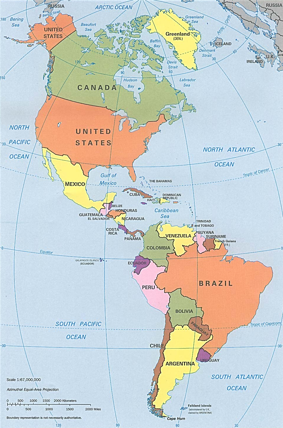
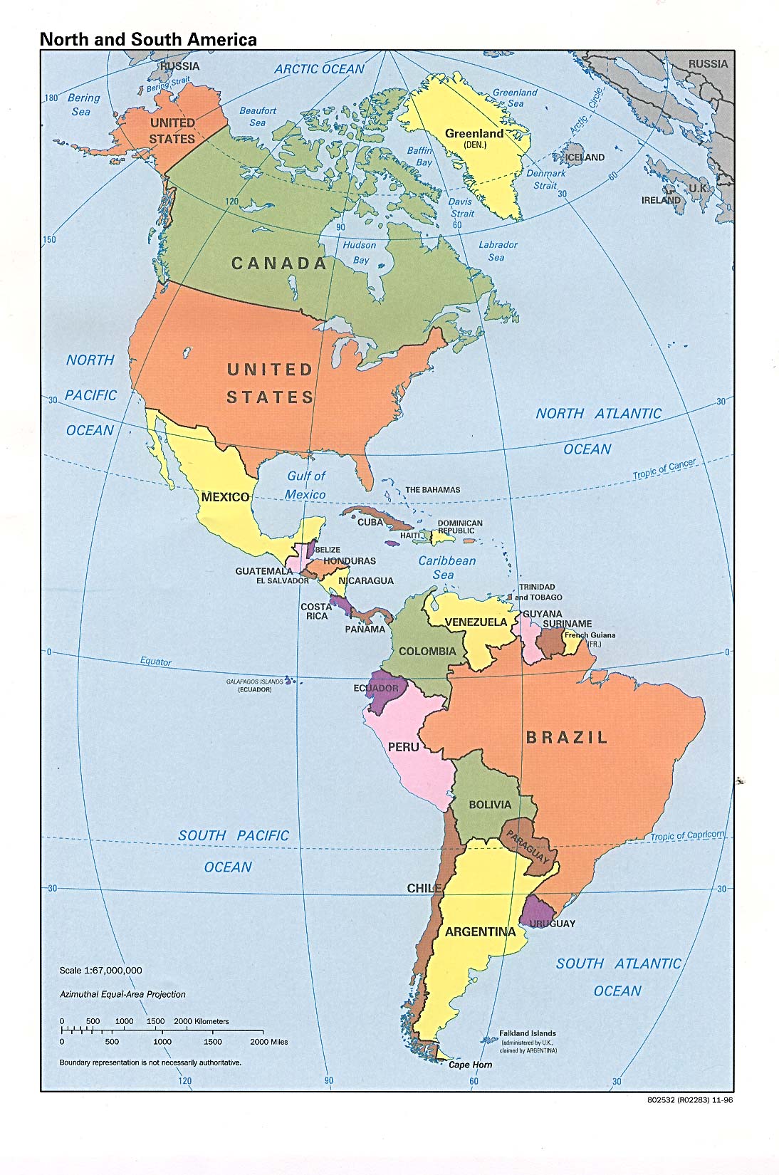
| Beskrivelse | Americas with political boundaries |
| Dato | |
| Kilde | http://www.lib.utexas.edu/maps/americas/americas_pol96.jpg |
| Forfatter | CIA, original political map from Perry-Castañeda Library Map Collection; University of Texas Library Online |
Licensering
[redigér]
| This image is a work of a Central Intelligence Agency employee, taken or made as part of that person's official duties. As a Work of the United States Government, this image or media is in the public domain in the United States.
|

|
Filhistorik
Klik på en dato/tid for at se filen som den så ud på det tidspunkt.
| Dato/tid | Miniaturebillede | Dimensioner | Bruger | Kommentar | |
|---|---|---|---|---|---|
| nuværende | 22. jan. 2023, 09:26 | | 964 × 1.455 (1,32 MB) | Lojwe (diskussion | bidrag) | Cropped 1 % horizontally, < 1 % vertically using CropTool with precise mode. |
| 12. jul. 2012, 16:51 |  | 970 × 1.460 (1,29 MB) | McZusatz (diskussion | bidrag) | cropped (used source file) | |
| 10. jan. 2010, 20:38 |  | 1.000 × 1.521 (286 KB) | Entheta (diskussion | bidrag) | cropped | |
| 25. mar. 2007, 18:32 |  | 1.094 × 1.650 (289 KB) | Corticopious (diskussion | bidrag) | North and South America: political map (CIA) |
Du kan ikke overskrive denne fil.
Filanvendelse
Der er ingen sider der bruger denne fil.
Global filanvendelse
Følgende andre wikier anvender denne fil:
- Anvendelser på an.wikipedia.org
- Anvendelser på ar.wikipedia.org
- Anvendelser på as.wikipedia.org
- Anvendelser på az.wikipedia.org
- Anvendelser på az.wiktionary.org
- Anvendelser på ba.wikipedia.org
- Anvendelser på ceb.wikipedia.org
- Anvendelser på el.wikipedia.org
- Anvendelser på en.wikipedia.org
- Anvendelser på es.wikipedia.org
- Anvendelser på es.wikiversity.org
- Anvendelser på fa.wikipedia.org
- Anvendelser på fi.wikipedia.org
- Anvendelser på fr.wikipedia.org
- Anvendelser på fr.wiktionary.org
- Anvendelser på fy.wikipedia.org
- Anvendelser på he.wikipedia.org
- Anvendelser på hi.wikipedia.org
- Anvendelser på hy.wikipedia.org
- Anvendelser på id.wikipedia.org
- Anvendelser på ig.wikipedia.org
- Anvendelser på ik.wikipedia.org
- Anvendelser på inh.wikipedia.org
- Anvendelser på it.wikipedia.org
- Anvendelser på ka.wikipedia.org
- Anvendelser på kcg.wikipedia.org
- Anvendelser på kk.wikipedia.org
- Anvendelser på km.wikipedia.org
- Anvendelser på kn.wikipedia.org
- Anvendelser på ko.wikipedia.org
- Anvendelser på la.wikipedia.org
- Anvendelser på lo.wikipedia.org
- Anvendelser på mk.wikipedia.org
- Anvendelser på ml.wikipedia.org
- Anvendelser på mn.wikipedia.org
- Anvendelser på mr.wikipedia.org
- Anvendelser på nds-nl.wikipedia.org
- Anvendelser på nl.wikipedia.org
- Anvendelser på no.wikipedia.org
- Anvendelser på pcd.wikipedia.org
- Anvendelser på pt.wikipedia.org
- Anvendelser på ru.wikipedia.org
Vis flere globale anvendelser af denne fil.