File:NOJHL Team Locations.svg
Jump to navigation
Jump to search

Size of this PNG preview of this SVG file: 360 × 300 pixels. Other resolutions: 288 × 240 pixels | 576 × 480 pixels | 922 × 768 pixels | 1,229 × 1,024 pixels | 2,458 × 2,048 pixels.
Original file (SVG file, nominally 360 × 300 pixels, file size: 29 KB)
Captions
Captions
Add a one-line explanation of what this file represents
Summary
[edit]
This W3C-unspecified vector image was created with Inkscape .
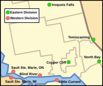
| Description | A map of Northeastern Ontario, showing the locations of teams in the Northern Ontario Junior Hockey League. |
| Date | |
| Source | Crop and trace of Image:Canada (geolocalisation).svg; trace of Image:Ontario subdivisions.PNG. |
| Author | Vidioman |
| Other versions | en:Image:NOJHL Canada-US Map.png |
.svg)
Licensing
[edit]
| I, the copyright holder of this work, release this work into the public domain. This applies worldwide. In some countries this may not be legally possible; if so: I grant anyone the right to use this work for any purpose, without any conditions, unless such conditions are required by law. |
File history
Click on a date/time to view the file as it appeared at that time.
| Date/Time | Thumbnail | Dimensions | User | Comment | |
|---|---|---|---|---|---|
| current | 22:18, 29 July 2008 | | 360 × 300 (29 KB) | Vidioman (talk | contribs) | {{Information |Description= |Source= |Date= |Author= |Permission= |other_versions= }} |
| 06:24, 13 October 2007 |  | 360 × 300 (24 KB) | Vidioman (talk | contribs) | {{Created with Inkscape}} {{Information |Description=A map of Northeastern Ontario, showing the locations of teams in the Northern Ontario Junior Hockey League. |Source=Crop and trace of [[:Image:Ca |
You cannot overwrite this file.
File usage on Commons
There are no pages that use this file.
File usage on other wikis
The following other wikis use this file:
- Usage on en.wikipedia.org