File:NPS arches-delicate-arch-map.jpg
Jump to navigation
Jump to search
Size of this preview: 799 × 277 pixels. Other resolutions: 320 × 111 pixels | 920 × 319 pixels.
Original file (920 × 319 pixels, file size: 100 KB, MIME type: image/jpeg)
Captions
Captions
Add a one-line explanation of what this file represents
Summary[edit]
| Description |
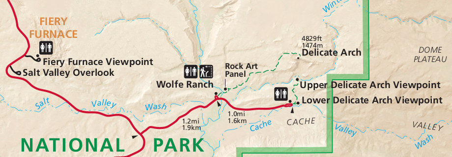
English: The Delicate Arch map shows the short hikes to the Delicate Arch viewpoints as well as the more strenuous 1.5-mile trail that leads to its base. Also here is the Fiery Furnace Overlook. |
| Date | |
| Source | U.S. National Park Service (http://npmaps.com/wp-content/uploads/arches-delicate-arch-map.jpg) |
| Author | U.S. National Park Service, restoration/cleanup by Matt Holly |
Licensing[edit]
| This image or media file contains material based on a work of a National Park Service employee, created as part of that person's official duties. As a work of the U.S. federal government, such work is in the public domain in the United States. See the NPS website and NPS copyright policy for more information. |
File history
Click on a date/time to view the file as it appeared at that time.
| Date/Time | Thumbnail | Dimensions | User | Comment | |
|---|---|---|---|---|---|
| current | 18:39, 13 May 2017 | 920 × 319 (100 KB) | RKBot (talk | contribs) | =={{int:filedesc}}== {{Information |description= {{en|1=The Delicate Arch map shows the short hikes to the Delicate Arch viewpoints as well as the more strenuous 1.5-mile trail that leads to its base. Also here is the Fiery Furnace Overlook.}} |date= 2... |
You cannot overwrite this file.
File usage on Commons
The following page uses this file: