File:NPS badlands-geologic-map-south.jpg
Jump to navigation
Jump to search

Size of this preview: 800 × 538 pixels. Other resolutions: 320 × 215 pixels | 640 × 430 pixels | 1,024 × 688 pixels | 1,280 × 860 pixels | 2,560 × 1,720 pixels | 4,262 × 2,864 pixels.
Original file (4,262 × 2,864 pixels, file size: 2.21 MB, MIME type: image/jpeg)
Captions
Captions
Add a one-line explanation of what this file represents
Summary
[edit]
| Description |
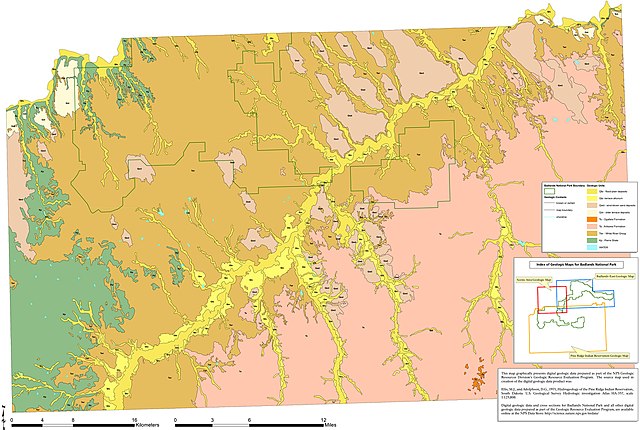
English: The Badlands south geologic map includes the Pine Ridge Indian Reservation lands as well as the southern part of the national park, which receives much fewer visitors than the areas north. |
| Date | |
| Source | U.S. National Park Service (http://npmaps.com/wp-content/uploads/badlands-geologic-map-south.jpg) |
| Author | U.S. National Park Service, restoration/cleanup by Matt Holly |
Licensing
[edit]
| This image or media file contains material based on a work of a National Park Service employee, created as part of that person's official duties. As a work of the U.S. federal government, such work is in the public domain in the United States. See the NPS website and NPS copyright policy for more information. |
File history
Click on a date/time to view the file as it appeared at that time.
| Date/Time | Thumbnail | Dimensions | User | Comment | |
|---|---|---|---|---|---|
| current | 12:00, 16 May 2017 | | 4,262 × 2,864 (2.21 MB) | RKBot (talk | contribs) | =={{int:filedesc}}== {{Information |description= {{en|1=The Badlands south geologic map includes the Pine Ridge Indian Reservation lands as well as the southern part of the national park, which receives much fewer visitors than the areas north.}} |date... |
You cannot overwrite this file.
File usage on Commons
The following page uses this file:
Categories:
- Geological maps of Badlands National Park
- Geologic formations in Badlands National Park
- Ogallala Formation - maps
- Arikaree Formation
- Pierre Shale in Badlands National Park
- Maps of the White River Group (geology)
- White River Group in Badlands National Park
- Pierre Shale - maps
- Quaternary floodplain deposits in South Dakota
- Quaternary alluvium in South Dakota
- Quaternary terrace deposits in South Dakota
- Quaternary aeolian sand deposits in South Dakota