File:NPS bandelier-geologic-map.jpg
Jump to navigation
Jump to search

Size of this preview: 800 × 483 pixels. Other resolutions: 320 × 193 pixels | 640 × 386 pixels | 1,024 × 618 pixels | 1,280 × 773 pixels | 2,560 × 1,546 pixels | 4,582 × 2,767 pixels.
Original file (4,582 × 2,767 pixels, file size: 4.58 MB, MIME type: image/jpeg)
Captions
Captions
Add a one-line explanation of what this file represents
Summary[edit]
| Description |
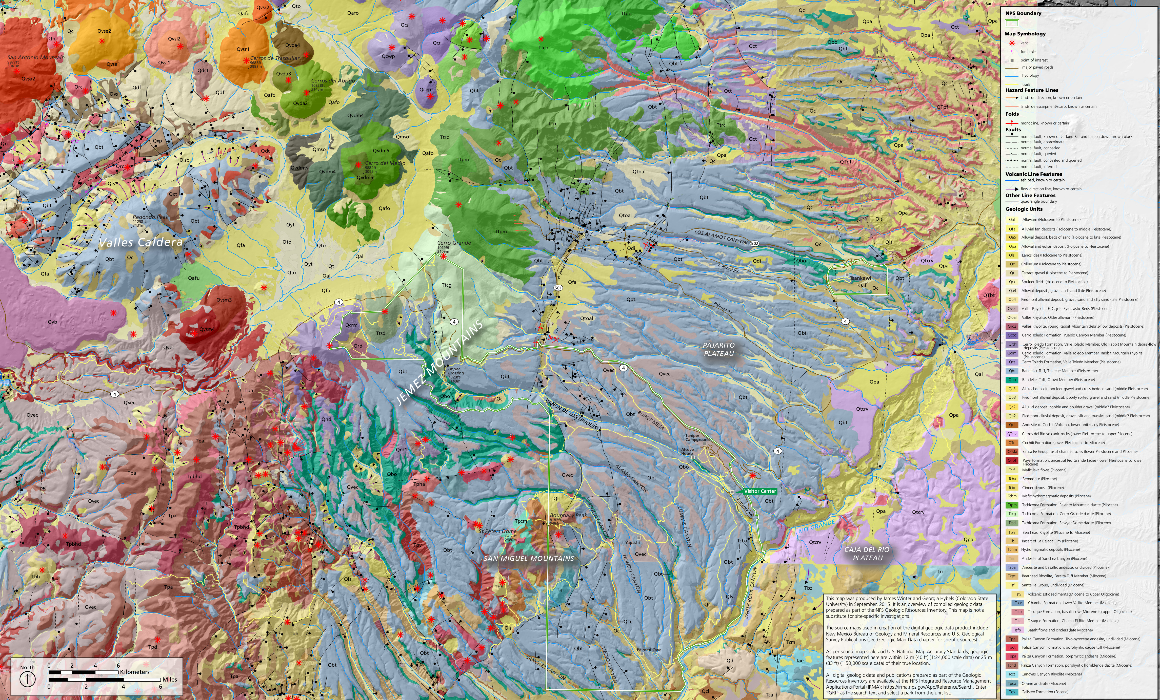
English: Bandelier geologic map, showing the variety of rock layers and geologic features inside Bandelier National Monument as well as nearby Valles Caldera National Preserve. |
| Date | |
| Source | U.S. National Park Service (http://npmaps.com/wp-content/uploads/bandelier-geologic-map.jpg) |
| Author | U.S. National Park Service, restoration/cleanup by Matt Holly |
Licensing[edit]
| This image or media file contains material based on a work of a National Park Service employee, created as part of that person's official duties. As a work of the U.S. federal government, such work is in the public domain in the United States. See the NPS website and NPS copyright policy for more information. |
File history
Click on a date/time to view the file as it appeared at that time.
| Date/Time | Thumbnail | Dimensions | User | Comment | |
|---|---|---|---|---|---|
| current | 16:25, 16 May 2017 | | 4,582 × 2,767 (4.58 MB) | RKBot (talk | contribs) | =={{int:filedesc}}== {{Information |description= {{en|1=Bandelier geologic map, showing the variety of rock layers and geologic features inside Bandelier National Monument as well as nearby Valles Caldera National Preserve.}} |date= 2017-01-13 |source=... |
You cannot overwrite this file.
File usage on Commons
The following page uses this file:
Categories:
- Maps of Bandelier National Monument
- Valles Caldera National Preserve
- Geological maps of New Mexico
- Maps of the Valles Caldera
- El Cajete Pyroclastic Beds
- Rabbit Mountain Debris Flow Deposits
- Pueblo Canyon Member, Toledo Formation
- Valle Toledo Member, Toledo Formation
- Rabbit Mountain Rhyolite
- Valles Rhyolite
- Bandelier Tuff
- Otowi Member, Bandelier Tuff
- Tsherige Member, Bandelier Tuff
- Andesite of Cochiti Volcano
- Cochiti Formation
- Cerros del Rio Pleistocene eruption products
- Cerros del Rio Pliocene eruption products
- Rio Grande Facies, Puye Formation
- Pliocene eruption products in New Mexico
- Pajarito Mountain Dacite
- Cerro Grande Dacite
- Sawyer Dome Dacite
- Tschicoma Formation
- Bearhead Rhyolite
- Basalt of La Bajada Rim (Valles Caldera)
- Andesite of Sanchez Canyon
- Peralta Tuff Member, Bearhead Rhyolite
- Lower Valito Member, Chamita Formation
- Tesuque Formation
- Chama-El Rito Member, Tesuque Formation
- Puye Formation
- Chamita Formation (U.S. geology)
- Santa Fe Group (United States) - maps
- Paliza Canyon Formation
- Canovas Canyon Formation
- Galisteo Formation
- Faults in New Mexico
- Eruptive vents in New Mexico
- Fumaroles in New Mexico
- Cerro Grande (New Mexico)