File:NPS glen-canyon-geologic-map-south.jpg
Jump to navigation
Jump to search

Size of this preview: 800 × 474 pixels. Other resolutions: 320 × 190 pixels | 640 × 380 pixels | 1,024 × 607 pixels | 1,280 × 759 pixels | 3,145 × 1,865 pixels.
Original file (3,145 × 1,865 pixels, file size: 2.13 MB, MIME type: image/jpeg)
Captions
Captions
Add a one-line explanation of what this file represents
Summary[edit]
| Description |
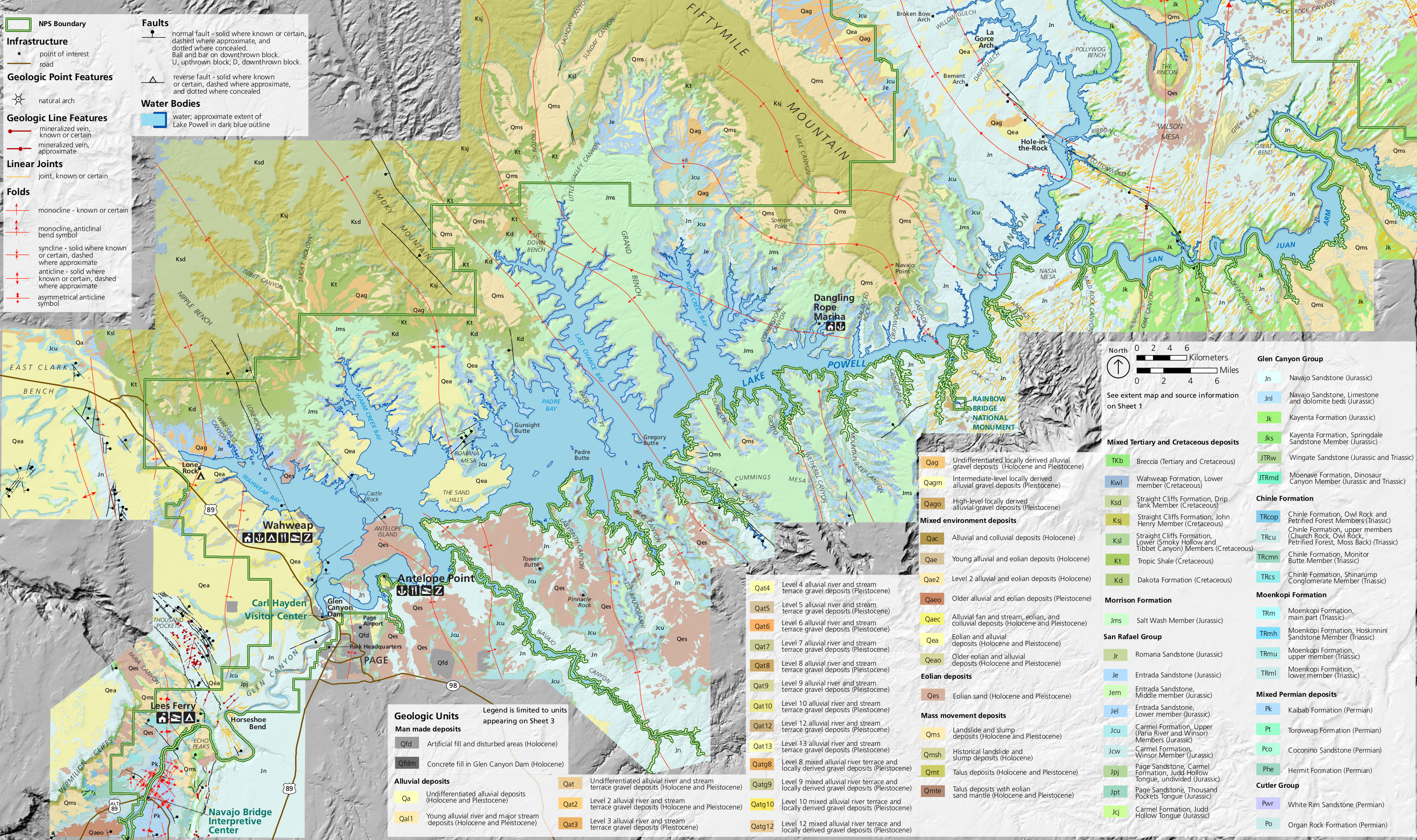
English: South Glen Canyon geologic map, focusing on the area around Glen Canyon Dam and the southernmost marinas on Lake Powell near the Utah/Arizona border |
| Date | |
| Source | U.S. National Park Service (http://npmaps.com/wp-content/uploads/glen-canyon-geologic-map-south.jpg) |
| Author | U.S. National Park Service, restoration/cleanup by Matt Holly |
Licensing[edit]
| This image or media file contains material based on a work of a National Park Service employee, created as part of that person's official duties. As a work of the U.S. federal government, such work is in the public domain in the United States. See the NPS website and NPS copyright policy for more information. |
File history
Click on a date/time to view the file as it appeared at that time.
| Date/Time | Thumbnail | Dimensions | User | Comment | |
|---|---|---|---|---|---|
| current | 23:03, 16 May 2017 | | 3,145 × 1,865 (2.13 MB) | RKBot (talk | contribs) | =={{int:filedesc}}== {{Information |description= {{en|1=South Glen Canyon geologic map, focusing on the area around Glen Canyon Dam and the southernmost marinas on Lake Powell near the Utah/Arizona border}} |date= 2017-05-09 |source= U.S. National Park... |
You cannot overwrite this file.
File usage on Commons
The following page uses this file:
Categories:
- Maps of Glen Canyon National Recreation Area
- Geological maps of Arizona
- Geological maps of Utah
- Quaternary deposits in the United States
- Holocene deposits in the United States
- Pleistocene deposits in the United States
- Quaternary sediments in Arizona
- Quaternary sediments in Utah
- Paleogene breccia in the United States
- Cretaceous breccia in the United States
- Glen Canyon Dam
- Lake Powell
- Wahweap Formation - maps
- Lower Member, Wahweap Formation
- Straight Cliffs Formation - maps
- Drip Tank Member, Straight Cliffs Formation
- John Henry Member, Straight Cliffs Formation
- Smoky Hollow Member, Straight Cliffs Formation
- Tibbet Canyon Member, Straight Cliffs Formation
- Tropic Shale - maps
- Dakota Formation - maps
- Morrison Formation maps
- Salt Wash Member, Morrison Formation
- San Rafael Group - maps
- Romana Sandstone
- Middle Member, Entrada Sandstone
- Lower Member, Entrada Sandstone
- Paria River Member, Carmel Formation
- Winsor Member, Carmel Formation
- Page Sandstone
- Judd Hollow Tongue, Carmel Formation
- Thousand Pockets Tongue, Carmel Formation
- Navajo Sandstone (Jurassic)
- Navajo Sandstone maps
- Kayenta Formation - maps
- Wingate Sandstone maps
- Moenave Formation - maps
- Glen Canyon Group - maps
- Owl Rock Member - maps
- Chinle Formation maps
- Petrified Forest Member - maps
- Church Rock Member - maps
- Moss Back Conglomerate - maps
- Monitor Butte Member, Chinle Formation
- Shinarump Conglomerate - maps
- Moenkopi Formation maps
- Moenkopi Formation, main part
- Hoskinnini Member, Moenkopi Formation
- Upper Member, Moenkopi Formation
- Lower Member, Moenkopi Formation
- Kaibab Limestone maps
- Coconino Sandstone - maps
- Toroweap Formation - maps
- Hermit Formation - maps
- White Rim Sandstone - maps
- Organ Rock Formation - maps