File:NPS saguaro-geologic-map-east.jpg
Jump to navigation
Jump to search

Size of this preview: 500 × 599 pixels. Other resolutions: 200 × 240 pixels | 401 × 480 pixels | 641 × 768 pixels | 855 × 1,024 pixels | 1,710 × 2,048 pixels | 3,283 × 3,932 pixels.
Original file (3,283 × 3,932 pixels, file size: 2.33 MB, MIME type: image/jpeg)
Captions
Captions
Add a one-line explanation of what this file represents
Summary[edit]
| Description |
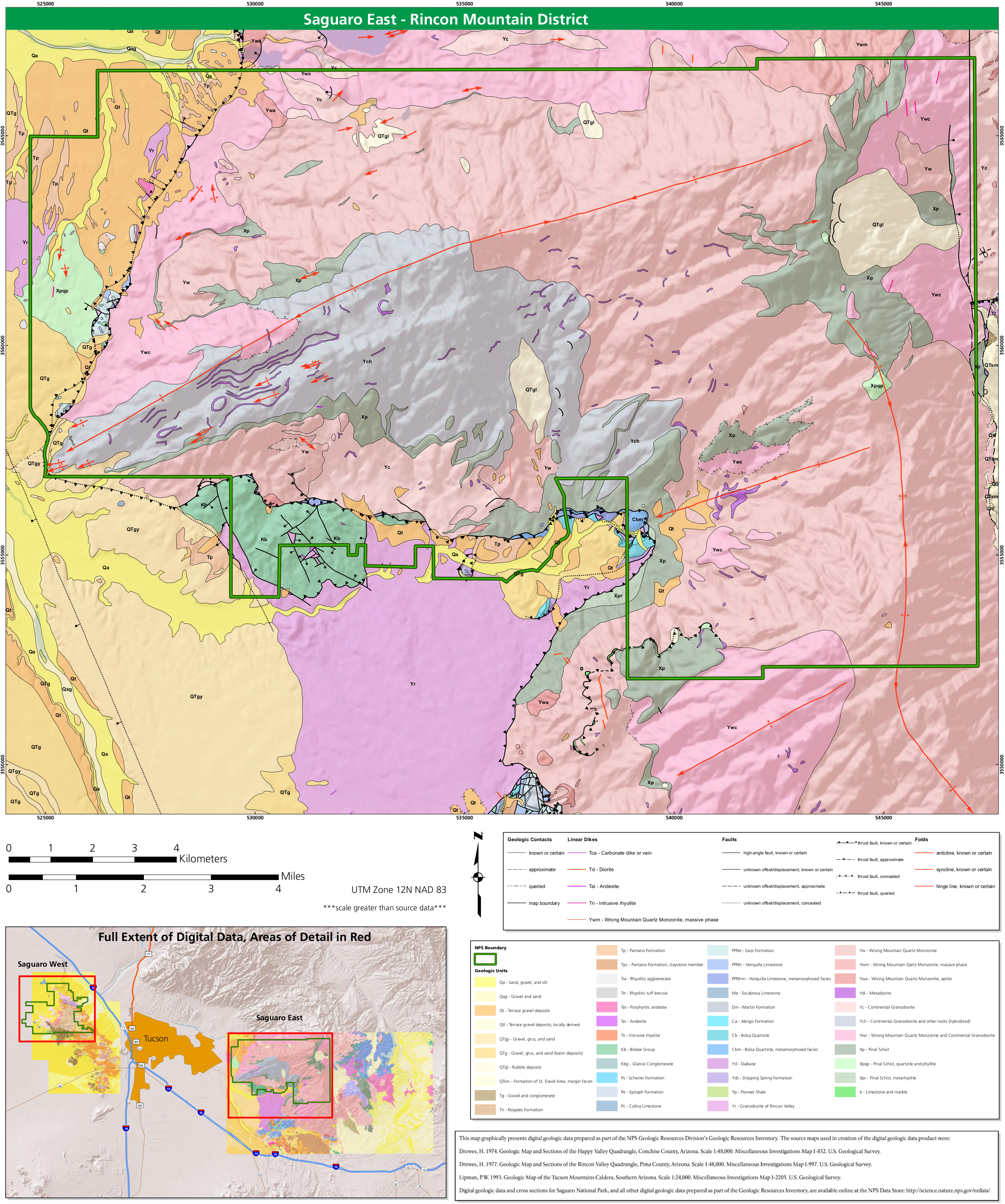
English: East Saguaro geologic map, which shows rock types, folds, and faults in the less-crowded, more-wildernessy Rincon Mountain district, east of the main part of Tucson. |
| Date | |
| Source | U.S. National Park Service (http://npmaps.com/wp-content/uploads/saguaro-geologic-map-east.jpg) |
| Author | U.S. National Park Service, restoration/cleanup by Matt Holly |
Licensing[edit]
| This image or media file contains material based on a work of a National Park Service employee, created as part of that person's official duties. As a work of the U.S. federal government, such work is in the public domain in the United States. See the NPS website and NPS copyright policy for more information. |
File history
Click on a date/time to view the file as it appeared at that time.
| Date/Time | Thumbnail | Dimensions | User | Comment | |
|---|---|---|---|---|---|
| current | 02:09, 17 May 2017 | | 3,283 × 3,932 (2.33 MB) | RKBot (talk | contribs) | =={{int:filedesc}}== {{Information |description= {{en|1=East Saguaro geologic map, which shows rock types, folds, and faults in the less-crowded, more-wildernessy Rincon Mountain district, east of the main part of Tucson.}} |date= 2017-01-20 |source= U... |
You cannot overwrite this file.
File usage on Commons
The following page uses this file:
Categories:
- Geological maps of Saguaro National Park
- Geological maps of Arizona
- Quaternary deposits in Saguaro National Park
- Nogales Formation
- Pantamo Formation
- Cenozoic rhyolitic tuffs and breccia
- Paleogene andesite in Arizona
- Neogene andesite in Arizona
- Paleogene rhyolitic intrusions
- Neogene rhyolitic intrusions
- Bisbee Group
- Glance Conglomerate
- Scherrer Formation
- Epitaph Formation
- Colina Limestone (Arizona)
- Earp Formation
- Horquilla Limestone (U.S. geology)
- Escabrosa Limestone (Arizona)
- Martin Formation
- Abrigo Formation (Arizona)
- Bolsa Quartzite (Arizona)
- Precambrian diabase in Arizona
- Dripping Spring Quartzite
- Pioneer Shale
- Granodiorite of Rincon Valley (Arizona)
- Quaternary sand in Arizona
- Quaternary silt in Arizona
- Quaternary gravel in Arizona
- Quaternary terrace gravel deposits in Arizona
- Quaternary rubble deposits in Arizona
- Formation of St. David Area
- Neogene gravel in Arizona
- Paleogene gravel in Arizona
- Neogene conglomerate in Arizona
- Paleogene conglomerate in Arizona
- Dikes (geology) in Arizona
- Andesite dikes in Arizona
- Diorite dikes in Arizona
- Rhyolitic dikes in Arizona
- Wrong Mountain Quartz Monzonite
- Continental Granodiorite
- Pinal Schist