File:NRHP South Carolina Map.svg
Jump to navigation
Jump to search

Size of this PNG preview of this SVG file: 776 × 600 pixels. Other resolutions: 311 × 240 pixels | 621 × 480 pixels | 994 × 768 pixels | 1,280 × 989 pixels | 2,560 × 1,978 pixels | 990 × 765 pixels.
Original file (SVG file, nominally 990 × 765 pixels, file size: 13.92 MB)
Captions
Captions
Add a one-line explanation of what this file represents
Summary[edit]
| Description |
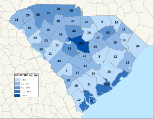
English: Map of South Carolina NRHP/100 sq. mi., by county. As of 1/8/10
|
||
| Date | 01/18/10 | ||
| Source | Own work | ||
| Author | 25or6to4 |
Licensing[edit]
I, the copyright holder of this work, hereby publish it under the following licenses:
This file is licensed under the Creative Commons Attribution-Share Alike 3.0 Unported license.
- You are free:
- to share – to copy, distribute and transmit the work
- to remix – to adapt the work
- Under the following conditions:
- attribution – You must give appropriate credit, provide a link to the license, and indicate if changes were made. You may do so in any reasonable manner, but not in any way that suggests the licensor endorses you or your use.
- share alike – If you remix, transform, or build upon the material, you must distribute your contributions under the same or compatible license as the original.

|
Permission is granted to copy, distribute and/or modify this document under the terms of the GNU Free Documentation License, Version 1.2 or any later version published by the Free Software Foundation; with no Invariant Sections, no Front-Cover Texts, and no Back-Cover Texts. A copy of the license is included in the section entitled GNU Free Documentation License. |
You may select the license of your choice.
File history
Click on a date/time to view the file as it appeared at that time.
| Date/Time | Thumbnail | Dimensions | User | Comment | |
|---|---|---|---|---|---|
| current | 08:52, 12 April 2022 | | 990 × 765 (13.92 MB) | 25or6to4 (talk | contribs) | Updated through March 2022 |
| 08:04, 24 March 2019 |  | 1,056 × 816 (3.6 MB) | 25or6to4 (talk | contribs) | Updated through March 1, 2019. | |
| 17:54, 3 April 2016 |  | 792 × 612 (2.38 MB) | 25or6to4 (talk | contribs) | Updated through January 1, 2016 | |
| 18:13, 15 September 2014 |  | 792 × 612 (2.37 MB) | 25or6to4 (talk | contribs) | Updated through September 2014 | |
| 07:37, 16 September 2012 |  | 792 × 612 (898 KB) | 25or6to4 (talk | contribs) | updated through August 2012 | |
| 22:10, 18 January 2010 |  | 792 × 612 (463 KB) | 25or6to4 (talk | contribs) | {{Information |Description={{en|1=Map of South Carolina NRHP/100 sq. mi., by county. As of 1/8/10}} |Source={{own}} |Author=25or6to4 |Date=01/18/10 |Permission= |other_versions= }} Category:Maps of South Carolina [[Category:Nationa |
You cannot overwrite this file.
File usage on Commons
There are no pages that use this file.
File usage on other wikis
The following other wikis use this file:
- Usage on en.wikipedia.org
- Usage on pt.wikipedia.org
- Usage on ro.wikipedia.org
- Categorie:Carolina de Sud
- Carolina de Sud
- Format:South Carolina stat SUA
- Columbia, Carolina de Sud
- Listă de comitate din statul Carolina de Sud
- Charleston, Carolina de Sud
- Listă de oameni din statul Carolina de Sud
- Listă de orașe din statul Carolina de Sud
- Categorie:Zona metropolitană Charleston – North Charleston – Summerville
- Categorie:Oameni din Carolina de Sud după comitat
- Comitatul Spartanburg, Carolina de Sud
- Categorie:Clădiri și structuri din statul Carolina de Sud
- Conway, Carolina de Sud
- Categorie:Zone metropolitane din Carolina de Sud
- Mark Sanford
- Categorie:Guvernatori ai statului Carolina de Sud
- Categorie:Absolvenți din Carolina de Sud după instituția de învățământ superior
- Categorie:Oameni din comitatul Charleston, Carolina de Sud
- Categorie:Comitatul Charleston, Carolina de Sud
- Categorie:Zone micropolitane din Carolina de Sud
- Categorie:Localități din Carolina de Sud
- Categorie:Comitatul Aiken, Carolina de Sud
- Categorie:Comitatul York, Carolina de Sud
- Categorie:Membri ai legislaturii statului Carolina de Sud
- Categorie:Oameni din comitatul Abbeville, Carolina de Sud
- Categorie:Liste Carolina de Sud
- Categorie:Columbia, Carolina de Sud
- Categorie:Guvernul statului Carolina de Sud
- Prefix telefonic 843 (Statele Unite ale Americii)
- Format:Sediile comitatelor din Carolina de Sud
- Categorie:Cioturi stat Carolina de Sud
- Sullivan's Island, Carolina de Sud
- Categorie:Târguri din statul Carolina de Sud
- Categorie:Municipalități din statul Carolina de Sud
- Categorie:Insule ale statului Carolina de Sud
- Categorie:Localități costale din Carolina de Sud
- Categorie:Localități din comitatul Charleston, Carolina de Sud
- Categorie:Geografia comitatului Charleston, Carolina de Sud
- Categorie:Locuri desemnate pentru recensământ din statul Carolina de Sud
- Categorie:Subdiviziunile statului Carolina de Sud
- Categorie:Istoria naturală a statului Carolina de Sud
- Categorie:Dezastre naturale din statul Carolina de Sud
- Categorie:Dezastre din statul Carolina de Sud
- Categorie:Politica statului Carolina de Sud
- Categorie:Legislatura statului Carolina de Sud
- Categorie:2012 în statul Carolina de Sud
- Categorie:Ani în Carolina de Sud
- Categorie:Uragane în statul Carolina de Sud
View more global usage of this file.