File:NSSL Project Vortex - Mobile Radar No.1 SE of Shamrock, Texas.jpg
Jump to navigation
Jump to search

Size of this preview: 800 × 519 pixels. Other resolutions: 320 × 208 pixels | 640 × 415 pixels | 1,024 × 664 pixels | 1,280 × 830 pixels | 1,832 × 1,188 pixels.
Original file (1,832 × 1,188 pixels, file size: 1.1 MB, MIME type: image/jpeg)
Captions
Captions
Add a one-line explanation of what this file represents
Summary
[edit]
| Description |
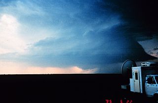
English: A mobile Doppler radar station (Doppler radar on wheels/DOW) southeast of Shamrock, Texas used in the first VORTEX project by the National Severe Storms Laboratory to study tornadoes. |
| Date | |
| Source | http://www.photolib.noaa.gov/htmls/nssl0156.htm |
| Author | NOAA Photo Library, NOAA Central Library; OAR/ERL/National Severe Storms Laboratory (NSSL) |
| Other versions | File:Tonado chasse NSSL.png - assembled with File:Project Vortex- filming a potentially tornadogenic storm.jpg |
Licensing
[edit]
This image is in the public domain because it contains materials that originally came from the U.S. National Oceanic and Atmospheric Administration, taken or made as part of an employee's official duties.
|
File history
Click on a date/time to view the file as it appeared at that time.
| Date/Time | Thumbnail | Dimensions | User | Comment | |
|---|---|---|---|---|---|
| current | 01:34, 12 February 2012 | | 1,832 × 1,188 (1.1 MB) | OjdvQ9fNJWl (talk | contribs) |
You cannot overwrite this file.
File usage on Commons
There are no pages that use this file.