File:NUTS 2 statistical regions of the United Kingdom map.svg
Ir a la navegación
Ir a la búsqueda

Tamaño de esta previsualización PNG del archivo SVG: 405 × 599 píxeles. Otras resoluciones: 162 × 240 píxeles | 324 × 480 píxeles | 519 × 768 píxeles | 692 × 1024 píxeles | 1384 × 2048 píxeles | 871 × 1289 píxeles.
Archivo original (archivo SVG, nominalmente 871 × 1289 píxeles, tamaño de archivo: 3,33 MB)
Leyendas
Leyendas
Añade una explicación corta acerca de lo que representa este archivo
Resumen
[editar]| Descripción |
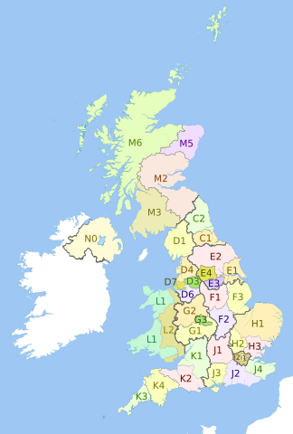
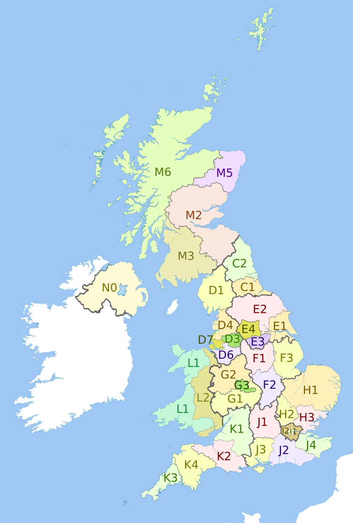
English: Map showing the NUTS 2 statistical regions of the United Kingdom in 2011.
Equirectangular map projection on WGS 84 datum, with N/S stretched 170% Geographic limits:
|
| Fecha | (UTC) |
| Fuente |
Este archivo deriva de: |
| Autor |
|


Licencia
[editar]
Este archivo se encuentra bajo la licencia Creative Commons Genérica de Atribución/Compartir-Igual 3.0.
Atribución: Dr Greg, Nilfanion, NordNordWest & XrysD. Contains Ordnance Survey data © Crown copyright and database right 2011
- Eres libre:
- de compartir – de copiar, distribuir y transmitir el trabajo
- de remezclar – de adaptar el trabajo
- Bajo las siguientes condiciones:
- atribución – Debes otorgar el crédito correspondiente, proporcionar un enlace a la licencia e indicar si realizaste algún cambio. Puedes hacerlo de cualquier manera razonable pero no de manera que sugiera que el licenciante te respalda a ti o al uso que hagas del trabajo.
- compartir igual – En caso de mezclar, transformar o modificar este trabajo, deberás distribuir el trabajo resultante bajo la misma licencia o una compatible como el original.
Registro original de carga
[editar]
This image is a derivative work of the following images:
- File:United_Kingdom_police_areas_map.svg licensed with Cc-by-sa-3.0
- 2011-10-12T11:33:39Z Nilfanion 871x1289 (2511111 Bytes) {{Information |Description=Map showing the [[w:Police areas|Police areas]] of the United Kingdom in 2011. Equirectangular map projection on WGS 84 datum, with N/S stretched 170% Geographic limits: *West: 11.0W *East: 2.2E *
- File:English_metropolitan_and_non-metropolitan_counties_2010.svg licensed with Cc-by-sa-3.0, GFDL
- 2010-11-23T22:01:59Z Nilfanion 1108x1345 (340057 Bytes) England only
- 2010-11-23T22:00:28Z Nilfanion 1108x1345 (376231 Bytes) {{Information |Description=Map showing the [[w:Metropolitan and non-metropolitan counties of England|Metropolitan and non-metropolitan counties of England]], in 2010. Equirectangular map projection on WGS 84 datum, with N/S
- File:Wales_location_map.svg licensed with Cc-by-sa-3.0
- 2009-06-24T13:27:54Z NordNordWest 1047x1252 (242334 Bytes) {{Information |Description= {{de|Positionskarte von [[:de:Wales|Wales]], [[:de:Vereinigtes Königreich|Vereinigtes Königreich]]}} Quadratische Plattkarte, N-S-Streckung 163 %. Geographische Begrenzung der Karte: * N: 53.5°
- File:Scottish_council_areas_2011.svg licensed with Cc-by-sa-3.0
- 2011-05-01T19:21:40Z Nilfanion 1023x1345 (3008417 Bytes) {{Information |Description=Map showing the [[w:Council areas of Scotland|Council areas of Scotland]] in 2011. Equirectangular map projection on WGS 84 datum, with N/S stretched 170% Geographic limits: *West: 8.8W *East: 0.4
- File:Scotland_Administrative_Map_1947.png licensed with Cc-by-sa-3.0-migrated, FAL, GFDL
- 2009-06-14T12:39:08Z XrysD 2000x3479 (2679270 Bytes) Corrected typo
- 2009-06-14T12:04:54Z XrysD 2000x3479 (2679081 Bytes) {{Information |Description={{en|1=Administrative map of Scotland in 1947. Showing Counties and Districts, Counties of Cities, Large and Smal Burghs}} |Source=Own work by uploader |Author=[[User:XrysD|XrysD]] |Date=2009-06-14
Uploaded with derivativeFX
Historial del archivo
Haz clic sobre una fecha y hora para ver el archivo tal como apareció en ese momento.
| Fecha y hora | Miniatura | Dimensiones | Usuario | Comentario | |
|---|---|---|---|---|---|
| actual | 21:27 6 sep 2012 | | 871 × 1289 (3,33 MB) | Dr Greg (discusión | contribs.) | Updated with 2010 changes: D2 replaced by D6, D5 replaced by D7 |
| 22:58 27 jul 2012 |  | 871 × 1289 (3,33 MB) | Dr Greg (discusión | contribs.) | == {{int:filedesc}} == {{Information |Description={{en|Map showing the en:NUTS 2 statistical regions of the United Kingdom in 2011. Equirectangular map projection on WGS 84 datum, with N/S stretched 170% Geographic limits: *West: 11.0W *Eas... |
No puedes sobrescribir este archivo.
Usos del archivo
La siguiente página usa este archivo: