File:NUTS 3 regions of North East England map.svg
Pereiti į navigaciją
Jump to search

Rinkmenos SVG peržiūros PNG dydisː 482 × 599 taškų. Kitos 6 rezoliucijos: 193 × 240 taškų | 386 × 480 taškų | 618 × 768 taškų | 824 × 1 024 taškų | 1 647 × 2 048 taškų | 1 082 × 1 345 taškų.
Pradinė rinkmena (SVG rinkmena, formaliai 1 082 × 1 345 taškų, rinkmenos dydis: 714 KiB)
Captions
Captions
Add a one-line explanation of what this file represents
Aprašymas[keisti]
| Aprašymas |
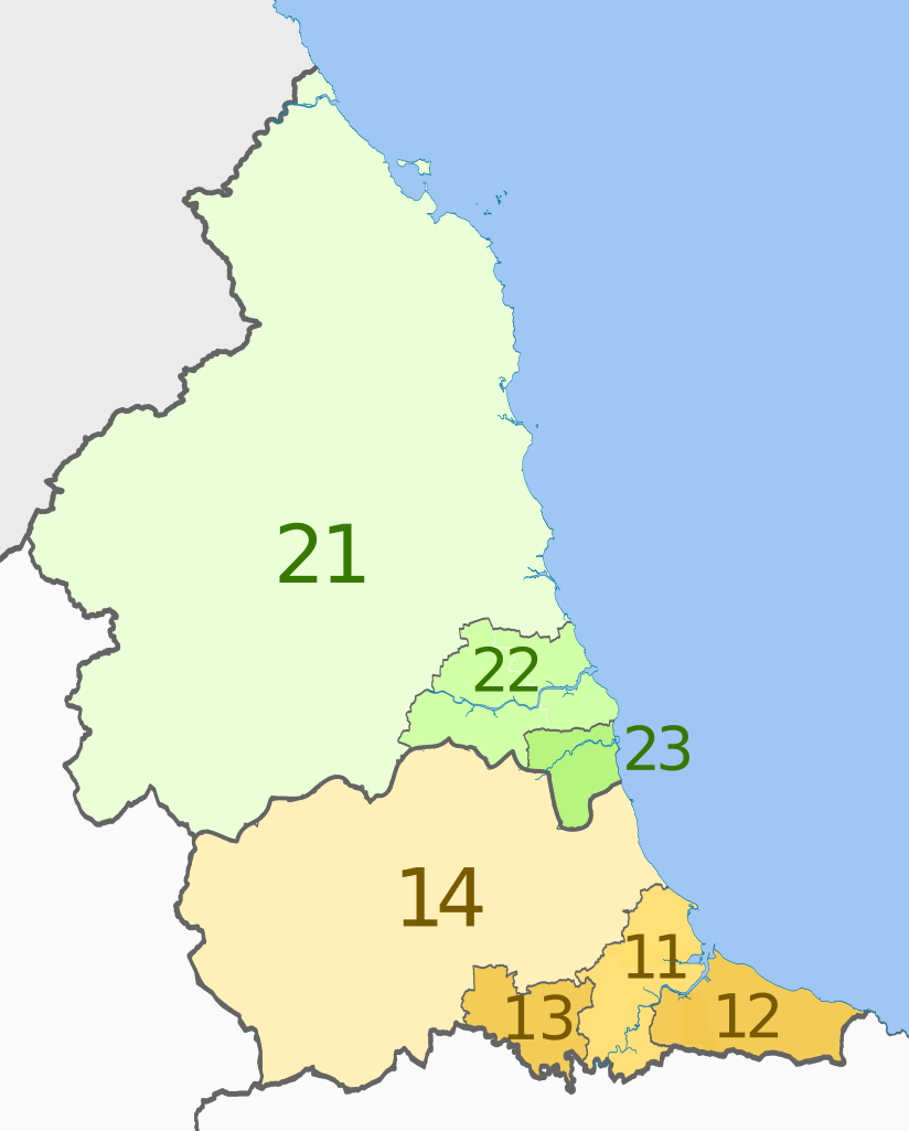
English: Map of the NUTS 3 regions of North East England.
Equirectangular map projection on WGS 84 datum, with N/S stretched 170% Geographic limits:
|
| Data | (UTC) |
| Šaltinis |
Šis failas buvo kilęs iš: |
| Autorius |
|


| NUTS 1 | Code | NUTS 2 | Code | NUTS 3 | Code |
|---|---|---|---|---|---|
| North East, England | UKC | Tees Valley and Durham | UKC1 | Hartlepool and Stockton-on-Tees | UKC11 |
| South Teesside (Middlesbrough and Redcar and Cleveland) | UKC12 | ||||
| Darlington | UKC13 | ||||
| Durham | UKC14 | ||||
| Northumberland and Tyne and Wear | UKC2 | ||||
| Northumberland | UKC21 | ||||
| Tyneside (Newcastle upon Tyne, Gateshead, South Tyneside, North Tyneside) | UKC22 | ||||
| Sunderland | UKC23 |
Licencija[keisti]
Šiam failui taikoma Creative Commons Attribution-Share Alike 3.0 Unported licencija.
Autoriaus nurodymas: Dr Greg and Nilfanion. Contains Ordnance Survey data © Crown copyright and database right 2011
- Jūs galite:
- dalintis – kopijuoti, platinti bei persiųsti šį darbą
- pri(si)taikyti – adaptuoti darbą
- Su šiomis sąlygomis:
- autoriaus nurodymas – Turite pateikti atitinkamą kreditą, pateikti nuorodą į licenciją ir nurodyti, ar buvo atlikti pakeitimai. Tai galite padaryti bet kokiu būdu, bet ne taip, kad licencijos išdavėjas patvirtintų jus ar jūsų naudojimą.
- dalinkis panašiai – Jei perdirbsite, redaguosite ar atkursite šį darbą, jį galėsite platinti tik su tokia pačia ar panašia į šią licencija.
Originalus įkėlimo įrašas[keisti]
This image is a derivative work of the following images:
- File:North_East_England__districts_2011_map.svg licensed with Cc-by-sa-3.0, GFDL
- 2011-05-01T18:56:43Z Nilfanion 1082x1345 (714062 Bytes) == Summary == {{Information |Description=Map of the [[w:North East England|North East England]] region showing the administrative districts. Equirectangular map projection on WGS 84 datum, with N/S stretched 170% Geographic
- File:English_ceremonial_counties_2010.svg licensed with Cc-by-sa-3.0, GFDL
- 2010-11-23T16:39:55Z Nilfanion 1108x1345 (308868 Bytes) thicker lines
- 2010-11-23T16:20:19Z Nilfanion 1108x1345 (301520 Bytes) tweaks
- 2010-10-26T20:34:20Z Nilfanion 817x990 (1391832 Bytes) {{Information |Description=Map showing the [[w:ceremonial counties of England]] including the City of London, in 2010. Equirectangular map projection on WGS 84 datum, with N/S stretched 170% Geographic limits: *West: 6.75W
Uploaded with derivativeFX
Rinkmenos istorija
Paspauskite ant datos/laiko, kad pamatytumėte rinkmeną tokią, kokia ji buvo tuo metu.
| Data/Laikas | Miniatiūra | Matmenys | Naudotojas | Paaiškinimas | |
|---|---|---|---|---|---|
| dabartinis | 21:27, 4 birželio 2012 | | 1 082 × 1 345 (714 KiB) | Dr Greg (aptarimas | indėlis) | == {{int:filedesc}} == {{Information |Description=Map of the NUTS 3 regions of North East England. Equirectangular map projection on WGS 84 datum, with N/S stretched 170... |
Jūs negalite perrašyti šios rinkmenos.
Rinkmenos naudojimas
Šis puslapis naudoja šią rinkmeną:
Visuotinis rinkmenos naudojimas
Ši rinkmena naudojama šiose viki svetainėse:
- Naudojama bn.wikipedia.org
- Naudojama de.wikipedia.org
- Naudojama en.wikipedia.org
- Naudojama fi.wikipedia.org
- Naudojama it.wikipedia.org
- Naudojama lt.wikipedia.org
- Naudojama ru.wikipedia.org
- Naudojama zh.wikipedia.org