File:NWS Upper air map 500mb 1998-01-05.gif
Aller à la navigation
Aller à la recherche
Taille de cet aperçu : 681 × 599 pixels. Autres résolutions : 273 × 240 pixels | 545 × 480 pixels | 752 × 662 pixels.
Fichier d’origine (752 × 662 pixels, taille du fichier : 315 kio, type MIME : image/gif)
Légendes
Légendes
Ajoutez en une ligne la description de ce que représente ce fichier
Description[modifier]
| Description |
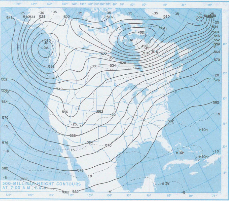
English: Upper air circulation at 500 mb during the North American ice storm of 1998. On January 5th, a long wave trough of low pressure was across the Rockies while a anti-cyclonic ridge was building across the East coast of the United States and Atlantic Ocean. This combination develops a persistent mild southwest flow the Gulf of Mexico to the northeast United States and southeast Canada where it has to turn to the East. The trough will move gradually East until the 10th but the eastward turn other the affected area will remain zonal.
Français : Circulation atmosphérique à 500 mb (environ 5,5 km d'altitude) durant le Verglas massif de 1998. Le 5 janvier, une onde longue de Rossby sur les montagnes Rocheuses et forme une creux barométrique à ce niveau qui amène de l'air doux du Golfe du Mexique sur le nord-est de l'Amérique du Nord. La circulation tourne vers l'Est à la hauteur du sud du Québec, empêchant cet air d'aller plus au nord. Le creux se déplacera lentement vers l'Est au cours des jours suivants mais pas la circulation zonale sur la zone affectée par le verglas. |
| Date | January 1998 but put into a web page on January 2008 |
| Source | http://www.erh.noaa.gov/btv/events/IceStorm1998/ice98.shtml |
| Auteur | National WEather Service Office in Burlington, Vermont |
Conditions d’utilisation[modifier]
Cette image est dans le domaine public car son contenu provient de la
National Oceanic and Atmospheric Administration , réalisé par un employé dans le cadre de ses activités professionnelles.
|
Historique du fichier
Cliquer sur une date et heure pour voir le fichier tel qu'il était à ce moment-là.
| Date et heure | Vignette | Dimensions | Utilisateur | Commentaire | |
|---|---|---|---|---|---|
| actuel | 12 juin 2009 à 18:13 | | 752 × 662 (315 kio) | Pierre cb (d | contributions) | {{Information |Description={{en|1=Upper air circulation at 500 mb during the North American ice storm of 1998. On January 5th, a long wave trough of low pressure was across the Rockies while a anti-cyclonic ridge w |
Vous ne pouvez pas remplacer ce fichier.
Utilisations locales du fichier
Aucune page n’utilise ce fichier.
Utilisations du fichier sur d’autres wikis
Les autres wikis suivants utilisent ce fichier :
- Utilisation sur fr.wikipedia.org
- Utilisation sur id.wikipedia.org
- Utilisation sur ja.wikipedia.org